TRAINMASTER
BY WERNER MEER US-RAILROAD-SHOP KILCHBERG
HOCHWEIDSTRASSE 3 CH-8802
KILCHBERG (ZÜRICH) SWITZERLAND (founded 1977)
PHONE *41-44-715-3666, FAX
*41-44-715-3660, E-MAIL trainmaster@bluewin.ch
Go back to our Website - click
here |
updated:
August 19, 2018: photo 8068
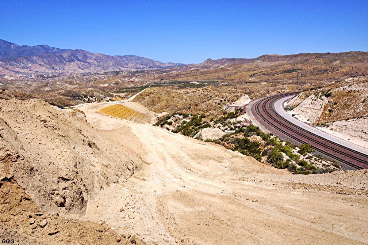
The project to
realign SR-138 is essentially complete and the road is fully open to traffic.
Cajon Pass Sub Photo
Collection
Highway 138 Realignment Project
2016 - 2017 - 2018 |
I am very pleased to show some exclusive photos of these photographers:
Don E. Toles (DET), Gary G. Gray (GGG), Marc Fournier (MF)
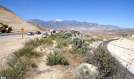
Bruce "Doc" Jones (BHJ), Keith Schreiber (KAS), Paul
Westover (PW)
Michael Frei (MIF) (more to follow)
A big thank you for sharing these excellent pictures with us.
Note: The copyright belongs to these gentlemen. Do not use any photos without
written permission.
|
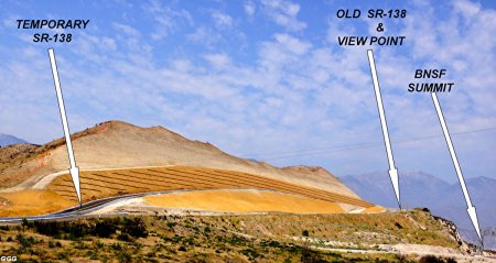
May 31, 2018: Highway 138
(East) Realignment Project is completed. |
For all who are familiar with Hwy 138 while
visitting Cajon Pass, are aware of the old two lane and curvy Highway 138
coming from exit # 131 (I-15) and going to Summit. Several years ago, Hwy
138 has been widened after the exit toward Summit for the first 1.9 mls. But
from that point up to Summit, it is a curvy up and down slow speed
(mountain) road. Three bridges and one undercrossing will be built.
(Hog Ranch Creek Bridge, Vjner's Shack Creek Bridge, OHV Undercrossing,
Double Drajn Cheek Bridge) |
 |
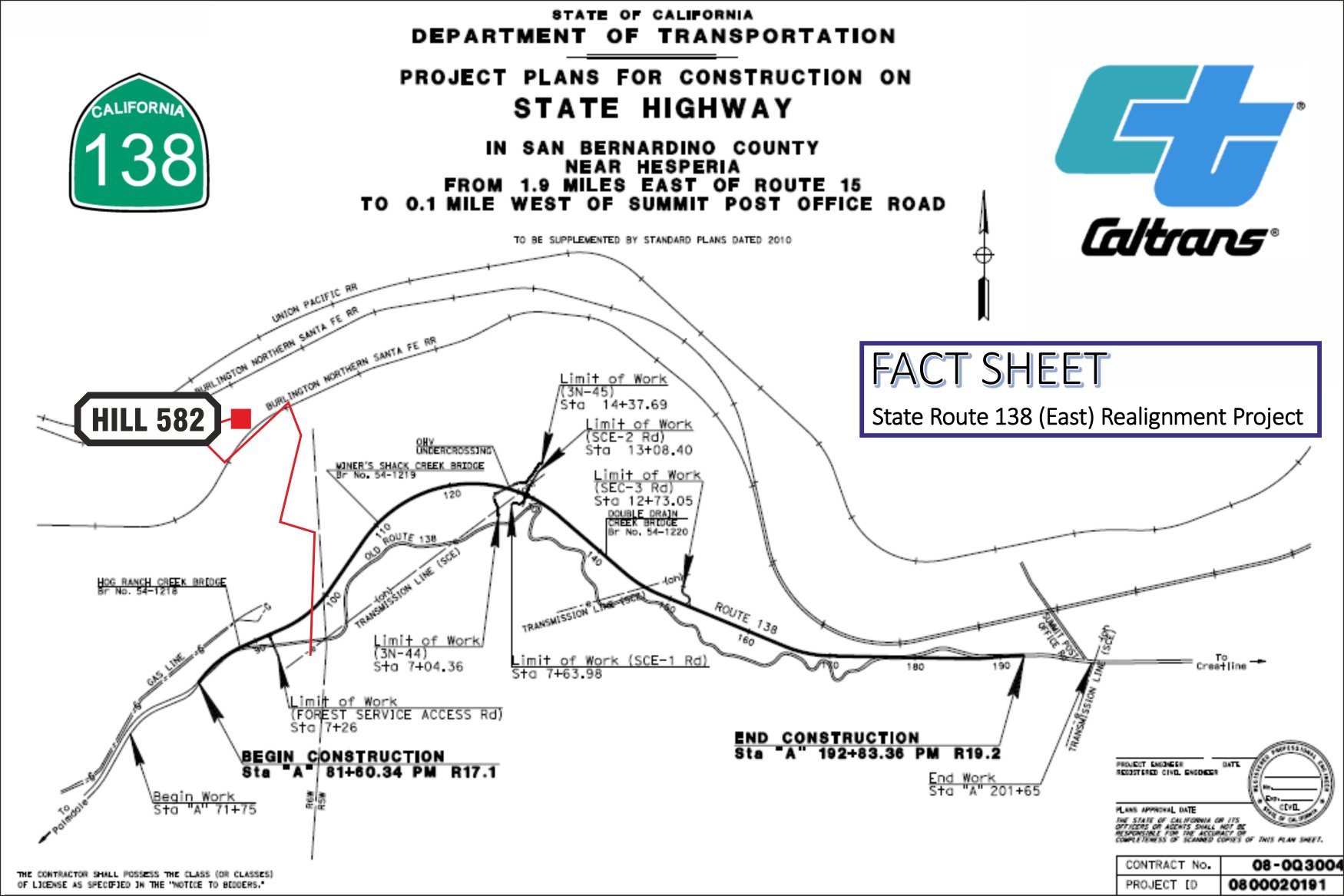
Map copyright by Caltrans and RUS -
6214
more infos:
http://www.dot.ca.gov/dist8/documents/sr138/SR-138-EAST-ALIGNMENT-FACT-SHEET-070716.pdf
more detailed infos with different maps:
http://www.spl.usace.army.mil/Portals/17/docs/publicnotices/SR138_realignment.pdf |

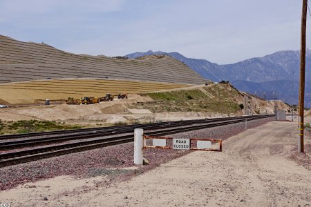
Hwy 138 looking toward Summit. Photo Courtesy
(copyright):
San Bernardino County Sherrif's Department

Hwy 138 is famous for the mountain style road
with tight curves, up and down with grade up to 15 %. Every railfan knows
this road very well while hanging around Cajon Pass.
Photo copyright: The Daily Press, Victorville, CA |

close up of Summit w/BNSF tracks. Photo
Courtesy (copyright):
San Bernardino County Sherrif's Department
 |
all photos are copyright by the original
photographer and as
mentioned with each picture. |
This curvy and hilly road will be history in
2018.
Photo copyright: The Daily Press, Victorville, CA |
Abbreviations found on this page: EB = East Bound, NB =
North Bound, SB = South Bound, WB = West Bound
For bigger size photos - please click on the 3-digit number below each
photo (the first letters specify the photographer).
|
October 29, 2016: Highway 138
(East) Realignment Project. Photos by Michael Frei. |
|
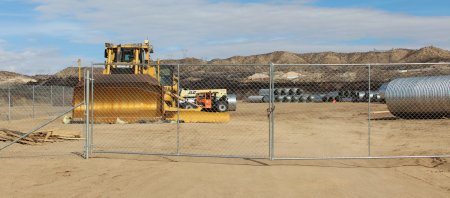
There is not much going on regarding the
construction in late October. Lots of equipment and huge pipes are on a
fenced site. |
 |
 |
|
MIF 10/29/16 -
001 |
MIF 10/29/16 -
002 |
 |
 |
|
MIF 10/29/16 -
003 |
MIF 10/29/16 -
004 |
 |
 |
|
MIF 10/29/16 -
005 |
MIF 10/29/16 -
006 |

updated: February 5, 2017
|
January 30, 2017: Highway 138
(East) Realignment Project. |
Don, Marc & I are doing our best to document
the realignment and rebuilding of CA SR (State Route) 138 between I-15 &
Cajon Summit. Any who have driven this existing "highway" know of its
amazing Roller Coaster / Switch Back (lack of safety)
design. The hills between the older & lower alignment and the new highway
make it difficult to photograph construction progress. GGG, MF,
DET
Pictures #008 - #013 were
taken between (A),
the
HWY 138 Summit & (BR-3)-Bridge
#3. |
 |
|
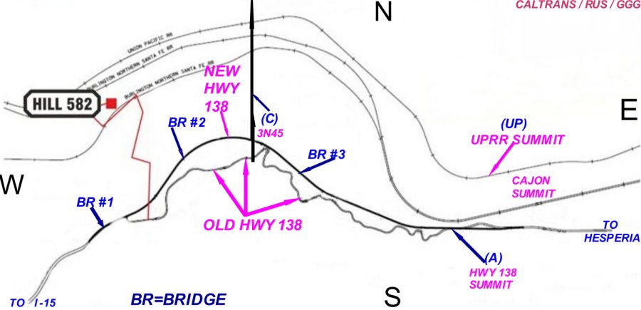
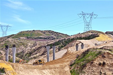
#1 I further edited a CALTRANS / RUS map of
the project. (A), (B), (BR) etc
identify our approximate Photo locations with
(BR-1, -2, or -3) also noting where
the three new bridges will be built. -
007 |
 |
 |
|
GGG 12/14/16
Looking Compass East, the new Summit route of
Hwy 138 can be seen. -
008 |
GGG 12/14/16
However, the new highway will be much lower -
close to BNSF track level. -
009 |
 |
 |
|
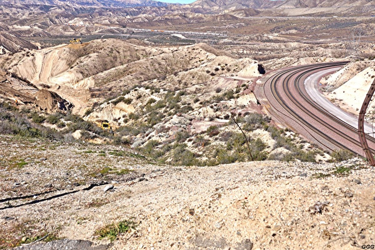
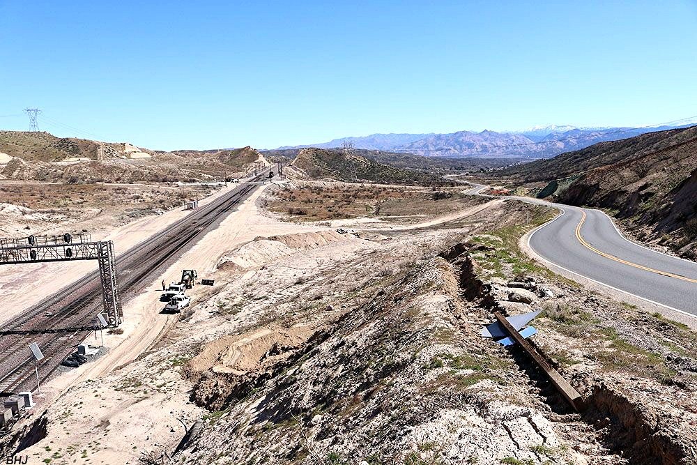
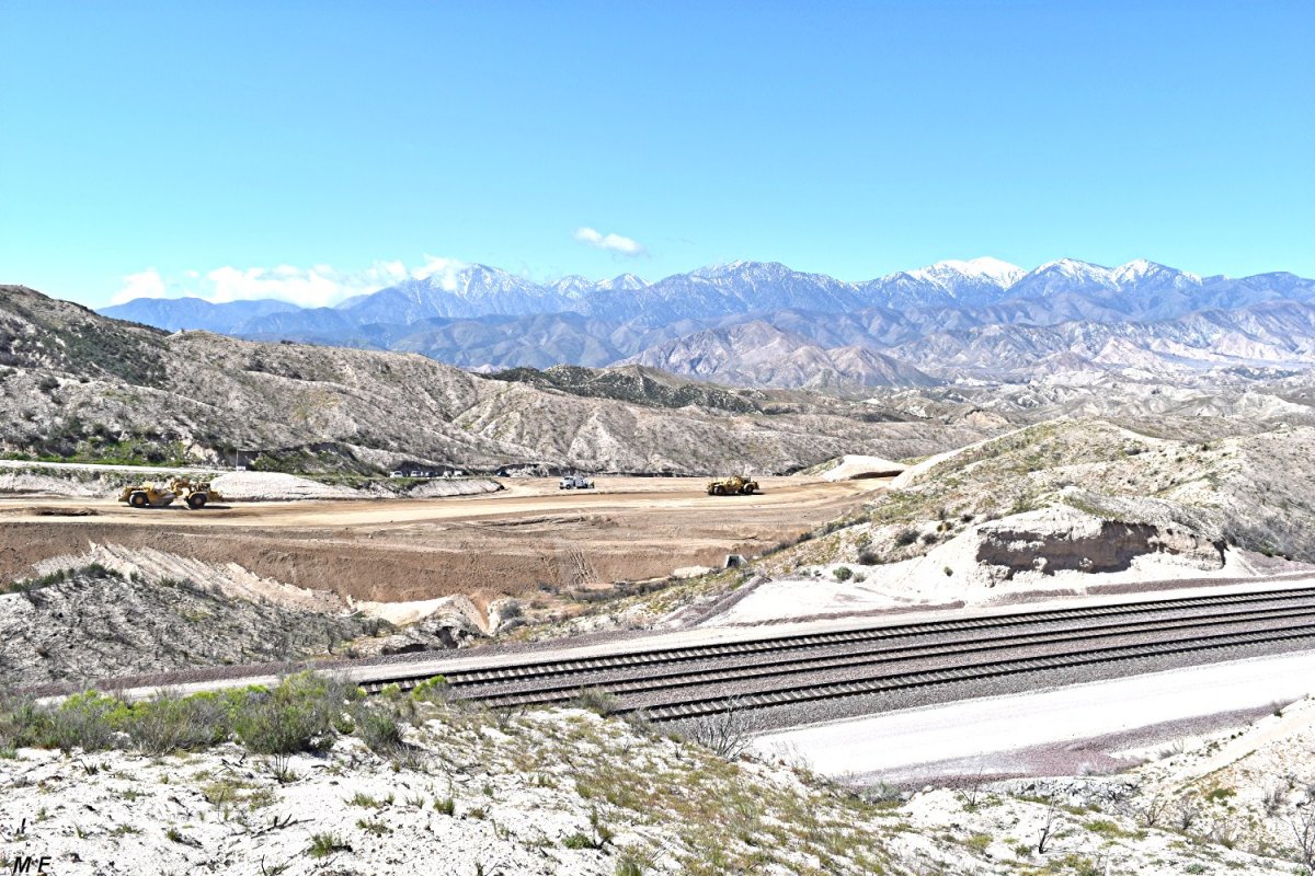
GGG 1/30/17
#010 Looking NW, track level and the new
highway excavation can be seen. -
010 |
GGG 1/30/17
#011 Looking W, the existing Hwy 138 and the
new route can be seen. -
011 |
 |
 |
|
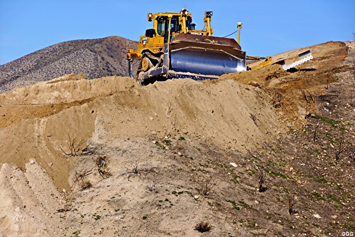
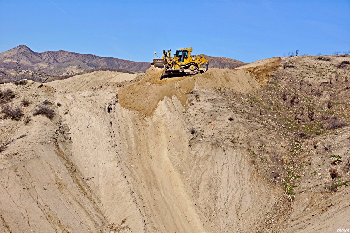
GGG 1/30/17 -
012
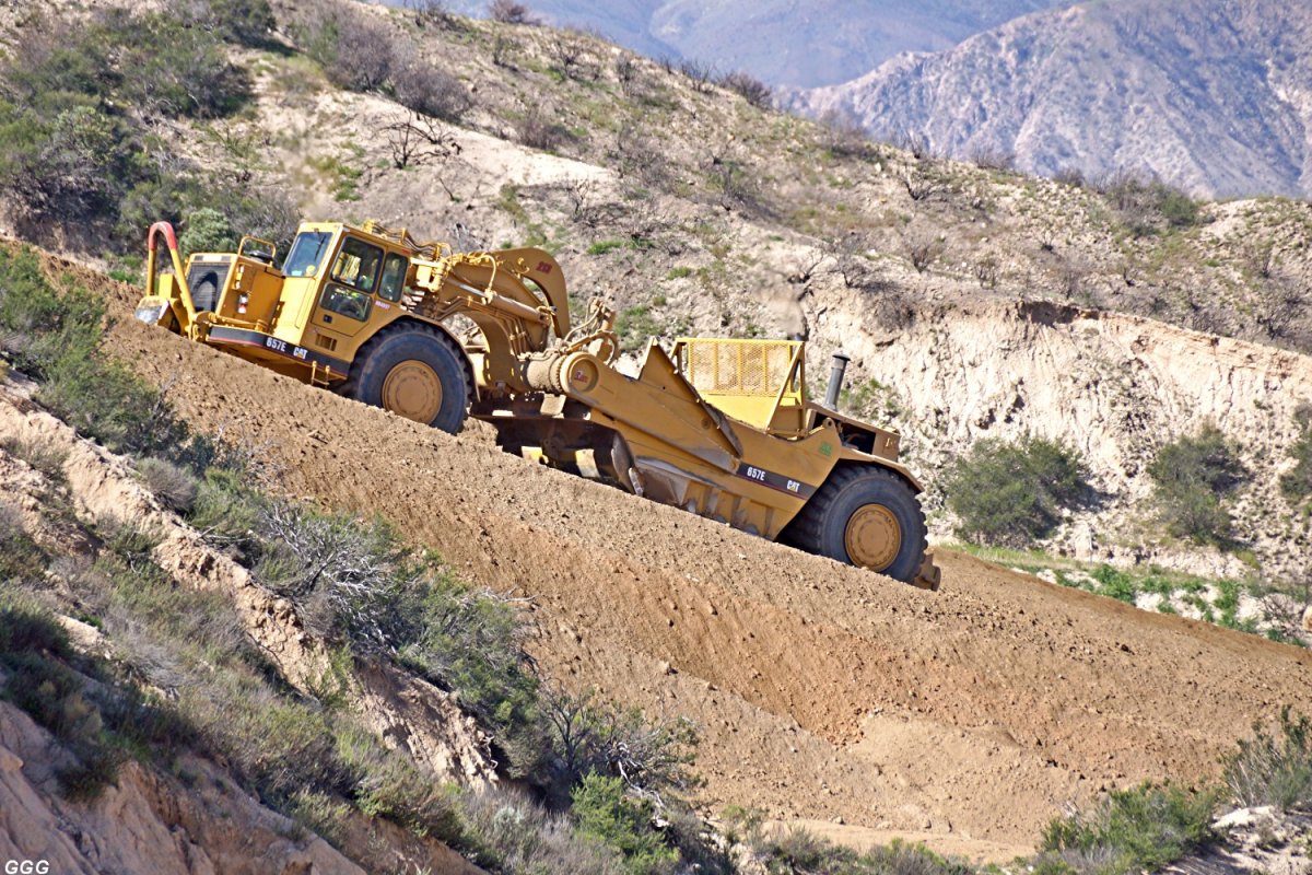
the World's bravest, or most skilled, - - - |
- - -
or most suicidal dozer operator.
GGG 1/30/17 -
013 |
 |
 |
|
GGG 1/30/17 -
014 |
GGG 1/30/17 -
015 |
|
#014 & #015 Looking East from
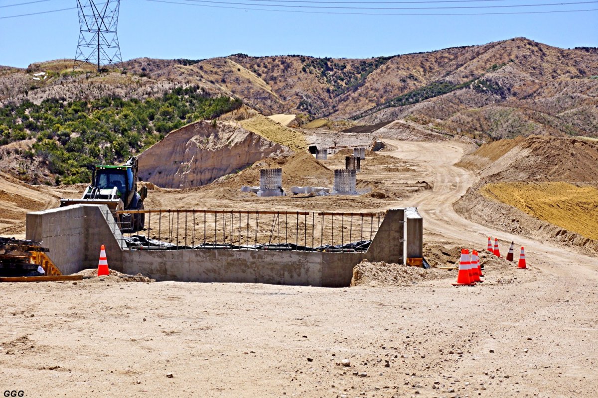
(BR-3), the Eastern abutment and
Eastern pier of Bridge 3 are pictured. It is our understanding that after
the abutments and piers are completed, the entire area will be filled in and
the bridge will be built on solid ground. That technique eliminates much of
the expensive false work & concrete pumping. Of course, after bridge
completion, the excess dirt will be dug out returning normal drainage to the
area. |
updated:
March 11, 2017
|
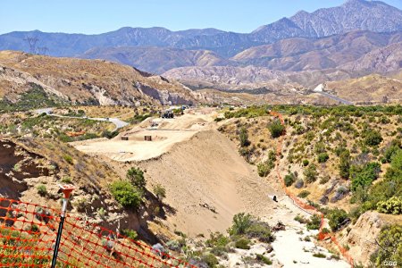
March 1, 2017: Highway 138
(East) Realignment Project. |
|
Bruce "Doc" Jones made some accurate pictures
on March 1 of the Hwy 138 construction site at Summit incl. 4 photos of
train action as seen from the Summit overlook. Please refer position
(A) and (BR #3) on
the map (007) above. |
 |
 |
|
BHJ 3/01/17
From Post Office Rd & Hwy 138, a view of the
Summit Overlook and the beginning changes to Hill above the overlook.
- 016 |
BHJ 3/01/17
Climbing to the Summit Overlook ----
(A)
on map - 017 |
 |
 |
|
BHJ 3/01/17 Climbing to the Summit Overlook
---- (A)
on map - 018 |
BHJ 3/01/17 From the Summit Overlook, East to
Post office RD. The new SR 138 alignment will connect to the present 138,
just this side of P. O. Road.
-
019 |
 |
 |
|
BHJ 3/01/17 From the Overlook, West showing
both old & new SR 138 alignments.
-
020 |
BHJ 3/01/17 From (BR
#3), pier & abutment progress on new
Bridge #3.
- 021 |
 |
 |
|
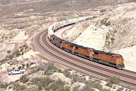
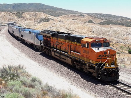
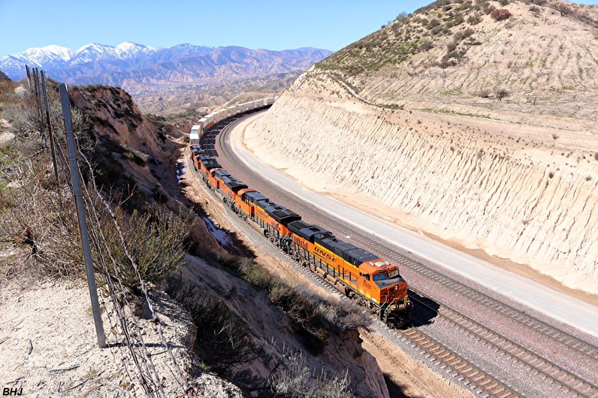
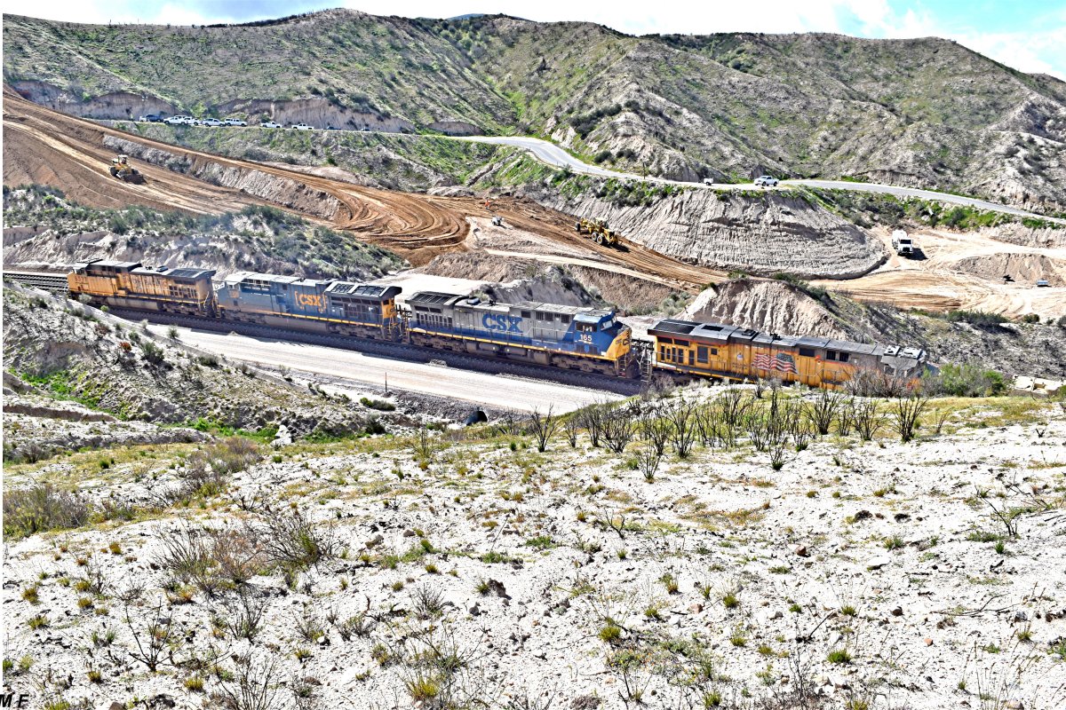
BHJ 3/01/17 BNSF 5000 EB on MT-1 from
Overlook - 022 |
BHJ 3/01/17 BNSF 6891 EB on MT-3 Summit Curve
- 023 |
 |
 |
|
BHJ 3/01/17 BNSF 6851 EB on MT-1 -
024 |
BHJ 3/01/17 BNSF 6949 WB from MT-3 to MT-2 -
025 |
|
March 9, 2017:
Highway 138 (East) Realignment
Project. |
|
I've was up at the Summit Overlook yesterday
(09 March 17) to get some stills and video before it comes down. I talked to
one of the field engineers from one of the contractors on the project and he
said indeed both the overlook and the big hill across the highway were
coming down. I'm assuming (that can be dangerous) that the overlook and the
hill will end up being fill in the ravine west of the overlook. All along
the route from the road to Hill 582 up to Summit there is a lot of
construction acitvity and grading. It's going to be a lot different up there
when they finish. Bruce "Doc" Jones |
BTW, there is a road
closure in effect from March 21 to April 4.
I'm assuming (dangerous again) that it will
begin at the I-15/138 junction. Not sure where it will be on the east end.
|
updated:
March 23, 2017
|
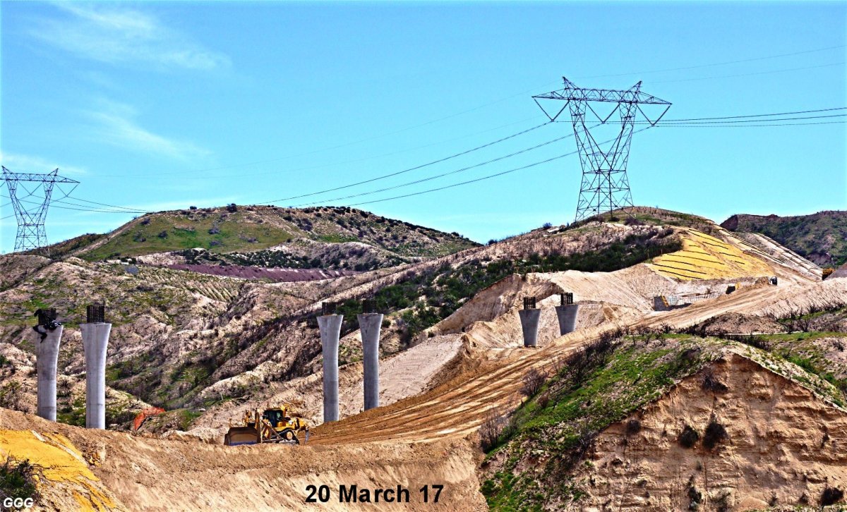
March 20, 2017: Highway 138
(East) Realignment Project. |
|
On 20 March, Marc & I decided to photograph
the 138 Cajon Summit area while we still had complete access. Naturally, we
had to visit Don on Hill 582 and wound up the day with lunch at DA DUMP.
GGG, MF & DET |
|
|
 |
 |
|
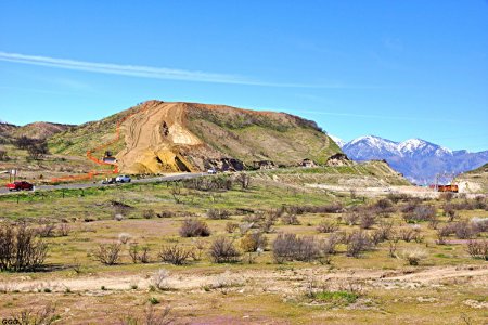
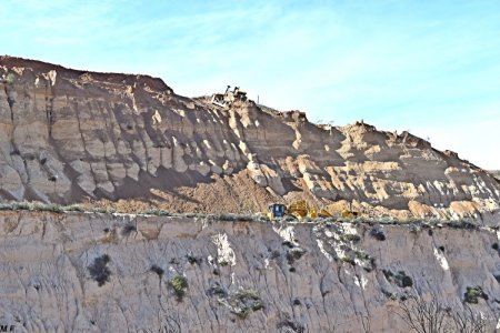
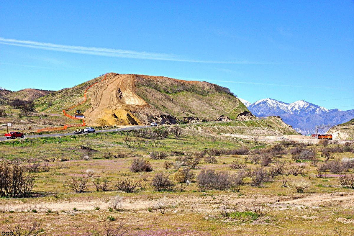
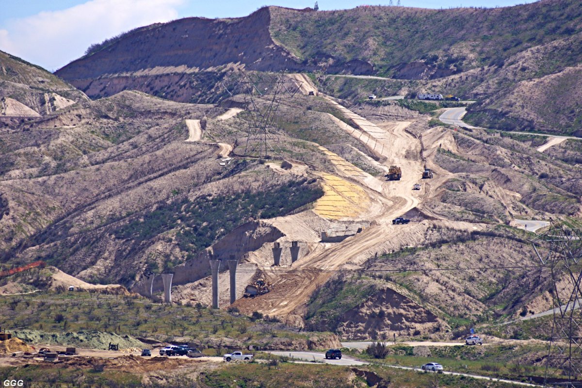
GGG 3/20/17 Summit Hill, the Summit overlook
& BNSF track level at Cajon Summit. It APPEARS that Most of Summit Hill will
be removed. We have been told that the new SR 138, at Summit, will be down
near BNSF track level. -
026 |
GGG 3/20/17 Close up of Summit Hill from Post
Office Road. In front is the current location Highway 138. -
027 |
 |
 |
|
GGG 3/20/17
From Summit Overlook
(A) on MAP, BNSF 7442 is EB with an
empty ethanol. -
028 |
GGG 3/20/17 From Summit Overlook, looking
West at old & new road alignments and drainage installation. -
029 |
 |
 |
|
From (BR #3),
the Eastern abutment & three sets of piers for Bridge #3 are shown. Much of
the dirt removed from Summit Hill will be used to build up the area to the
tops of the abutments so that the bridge can be built on solid ground. This
technique will eliminate the tremendous cost of building all of the support
structure & 'false work', strong enough to support tons & tons of steel and
concrete 30+ feet above the existing grade. Obviously, after bridge
construction is complete, the supporting dirt will be removed and the
terrain restored to it's present contours. |
|
GGG 3/20/17 -
030 |
GGG 3/20/17 -
031 |
 |
 |
|
GGG 3/20/17 View of Bridge #3 and the road
alignment East toward Cajon Summit. -
032 |
GGG 3/20/17
View FROM HILL 582, the eastern half of the project is
shown starting at Bridge #3. -
033 |
updated:
March 29, 2017
|
March 22, 2017: Highway 138
(East) Realignment Project. |
With the SR 138 closure, MAD Marc has spent
the last few days searching for and finding a new viewpoint to show the
project. The work, for the last week, has centered on cutting away the
Summit Hill (above the Summit Overlook).
Marc's new vantage is across the BNSF triple mains from the SR 138 Summit
Overlook. As normal with MAD MARC, the off the road King, getting there is
MORE THAN HALF the "FUN". This new
place where no man has ever wanted to go is now officially known as
MARC'S MADNESS !!!
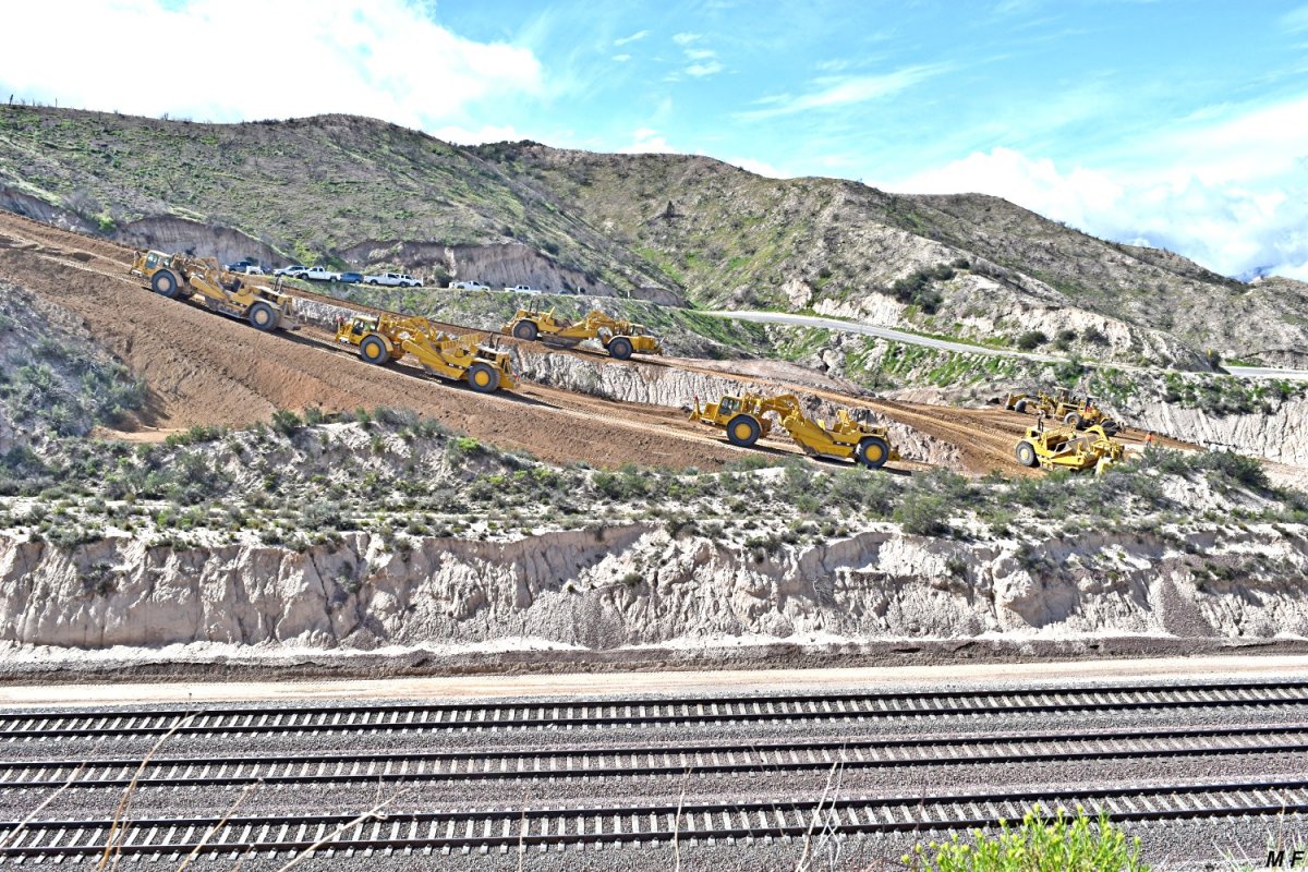
Using eight twin engine
"scrapers", three HUGE "dozers", and numerous generator powered flood
lights, the excavation has continued for, at least, two
shifts per day & six days a week.
MF |
 |
 |
|
MF 3/22/17 Overview of Summit Overlook Hill.
- 034 |
MF 3/22/17 Six of the eight scrapers climb
the very steep ramp on the East end of the Hill, scrape a load and ----
- 035 |
 |
 |
|
MF 3/22/17 -
036 |
MF 3/22/17 -
037 |
|
Descend the even steeper WEST ramp to deposit
their loads to elevate the canyon between the Overlook and Bridge #3---
(A) &
(BR#3) on map. Note that 'down ramp' was built over the
existing SR 138. When empty, the scrappers climb the shorter ramp up to SR
138, travel East and repeat the process. Of course, SR 138 is still closed
for any traffic and should be reopened after April 4. |
 |
 |
|
MF 3/22/17
Empty scrappers climb the shorter ramp up to SR 138, travel East and go up
(photo 035) to load dirt. -
038 |
MF 3/22/17 While a scrapper travels East on
SR 138 to grab another load, a precariously placed dozer pushes dirt over
the side of the Hill. -
039 |
 |
 |
|
MF 3/22/17 BNSF 6793 is WB under the Overlook
& ramps. - 040 |
MF 3/22/17 BNSF 6793 is WB under heavy
equipment - 041 |
|
While photographing the realignment of SR
138, we have been treated to numerous rollby's from both the UP & BNSF.
MF / GGG |
 |
 |
|
MF 3/22/17 UP 2594 SB at UP Hiland siding
(Cajon Summit) - 052 |
MF 3/22/17 UP 5465 DPU's SB at UP Hiland
siding (same train) - 053 |
 |
 |
|
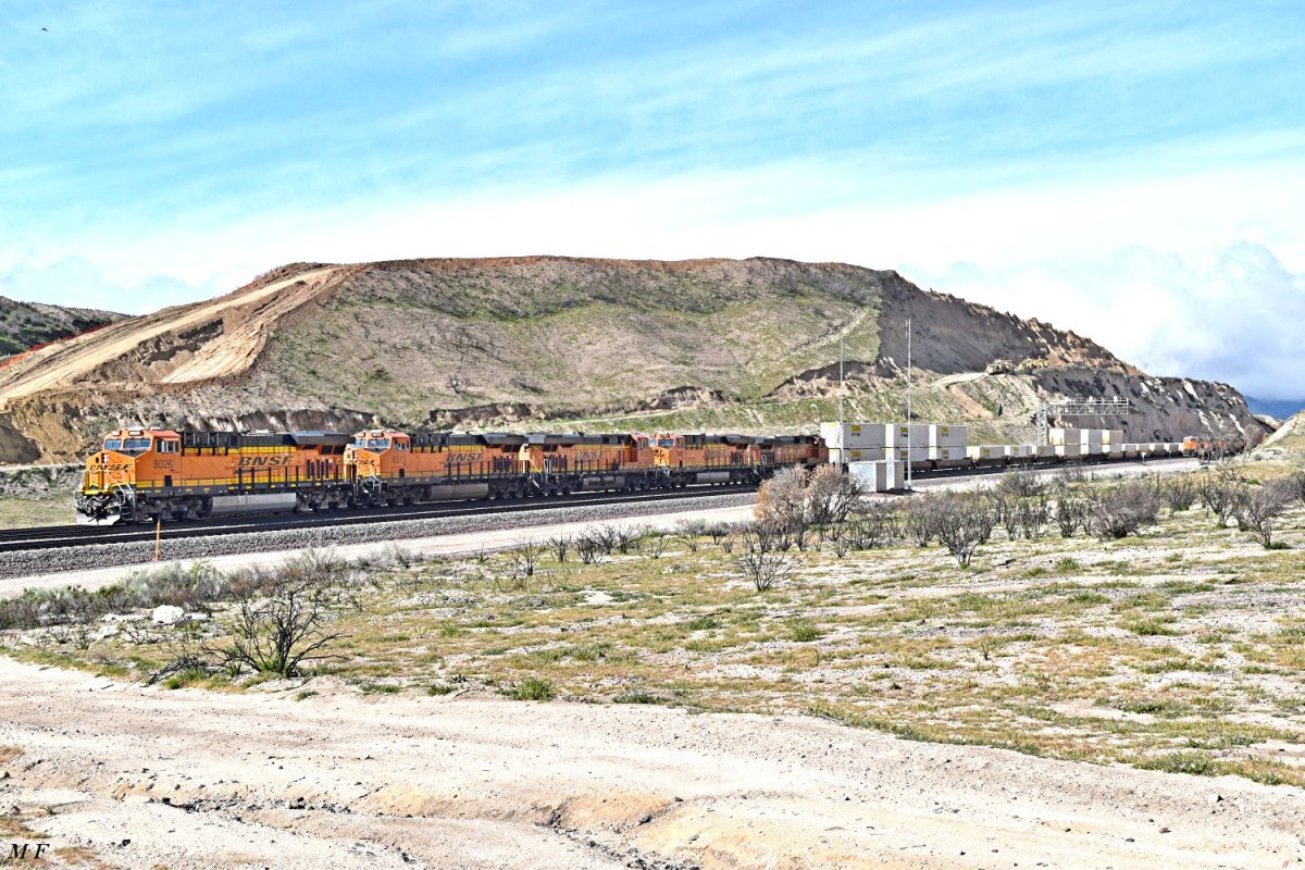
MF 3/22/17 Project Overview of Summit
Overlook Hill - 054 |
MF 3/22/17 BNSF 8026 East approaches Summit -
055 |
 |
 |
|
MF 3/22/17 BNSF 7844 West passes the first
(of two) UP EB military trains near WSI -
056 |
MF 3/22/17 BNSF 7829 is EB at Summit curve -
057 |
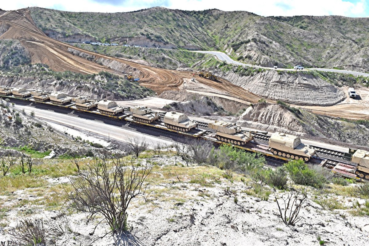
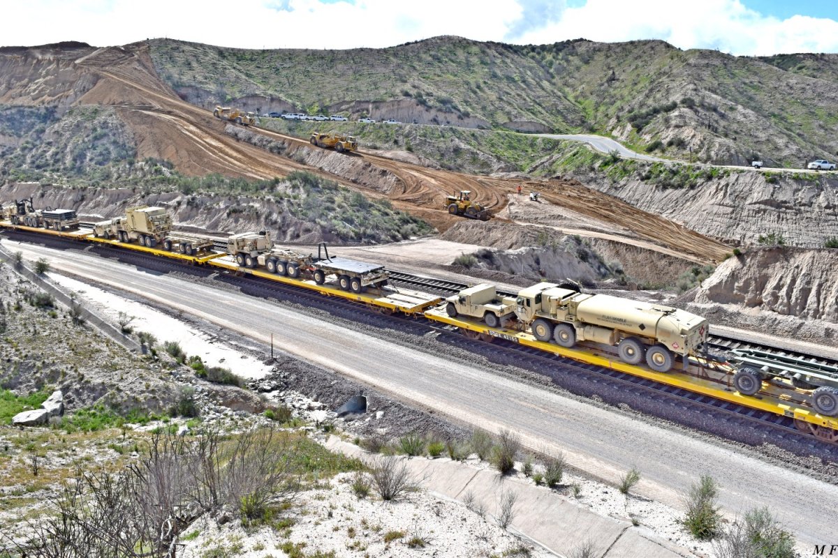
#058-065: UP 6577 with CSX is EB with a
second military train. The train, probably headed to Yermo / Ft Irwin,
carries equipment of the 3rd Infantry Division including M109A6 155mm Self
Propelled Howitzers, M992A3 ammunition support vehicles and various other
support vehicles.
Thanks to US Army Colonel (ret) Chuck Donaldson for his help in ID'ing the
military equipment. |
 |
 |
|
MF 3/22/17 UP 6577 EB -
058 |
MF 3/22/17 -
059 |
 |
 |
|
MF 3/22/17 -
060 |
MF 3/22/17 -
061 |
 |
 |
|
MF 3/22/17 -
062 |
MF 3/22/17 -
063 |
 |
 |
|
MF 3/22/17 -
064 |
MF 3/22/17 -
065 |
updated:
March 29, 2017
|
March 24, 2017: Highway 138
(East) Realignment Project. |
|
As reported, the Summit Overlook hill is
being lowered / destroyed using eight HUGE scrapers and three equally HUGE
dozers. Interesting to us were the steep inclines and seemingly dangerous
"perches" these machines and their operators work on. To take the attached
pictures, I made SURE that the camera was absolutely LEVEL--- horizontality.
GGG & MF |
 |
 |
|
GGG 3/24/17 -
042 |
GGG 3/24/17 -
043 |
|
# 042-045: The machines climb the East slope
of the Summit Overlook Hill. |
 |
 |
|
GGG 3/24/17 -
044 |
GGG 3/24/17 -
045 |
 |
 |
|
GGG 3/24/17
To closely photograph the Western ramps, it
is necessary to get to Marc's Madness. Pictured is ONE of the deep and/or
soft ground obstacles that must be negotiated.
-
046 |
GGG 3/24/17
From the Western end of the hill, loaded scrappers descending the ramp, on
the right, were lowering and dragging their buckets to aid in braking.
- 047 |
 |
 |
|
GGG 3/24/17
It appeared the scrappers were really
laboring to climb the return (to old SR 138) ramp.
-
048 |
GGG 3/24/17
The dirt was used to raise the new alignment, between the summit curve and
the new bridge #3. -
049
click here: 138-029-04-GGG-03-20-17.jpg |
 |
 |
|
MF 3/24/17 -
050 |
MF 3/24/17 -
051 |
|
Piers & West abutment for Bridge #3. Again,
this area will be totally filled- in so that the bridge can be built on
solid ground. |
|
To finish with the trains we've photographed
while documenting the SR138 realignment project, here are the last ten.
MF / GGG |
 |
 |
|
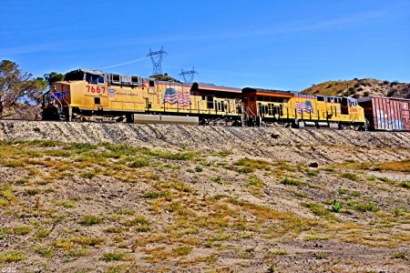
GGG 3/24/17 UP 7667 is SB at UP Cajon Summit
(Hiland) - 066 |
GGG 3/24/17 UP 7273 DPU SB at UP Cajon Summit
(same train) - 067 |
 |
 |
|
GGG 3/24/17 From above the UP Cajon Summit,
UP 7643 is NB to Palmdale -
069 |
GGG 3/24/17 From above the UP Cajon Summit UP
8684 SD70ACe DPU NB on same train to Palmdale -
070 |
 |
 |
|
GGG 3/24/17 BNSF / UP power mix is WB on the
BNSF just RR West of Summit -
068 |
MF 3/24/17 With the UP Cajon Summit tracks in
the foreground, a view of Summit Hill as of 03-24-17 -
075 |
 |
 |
|
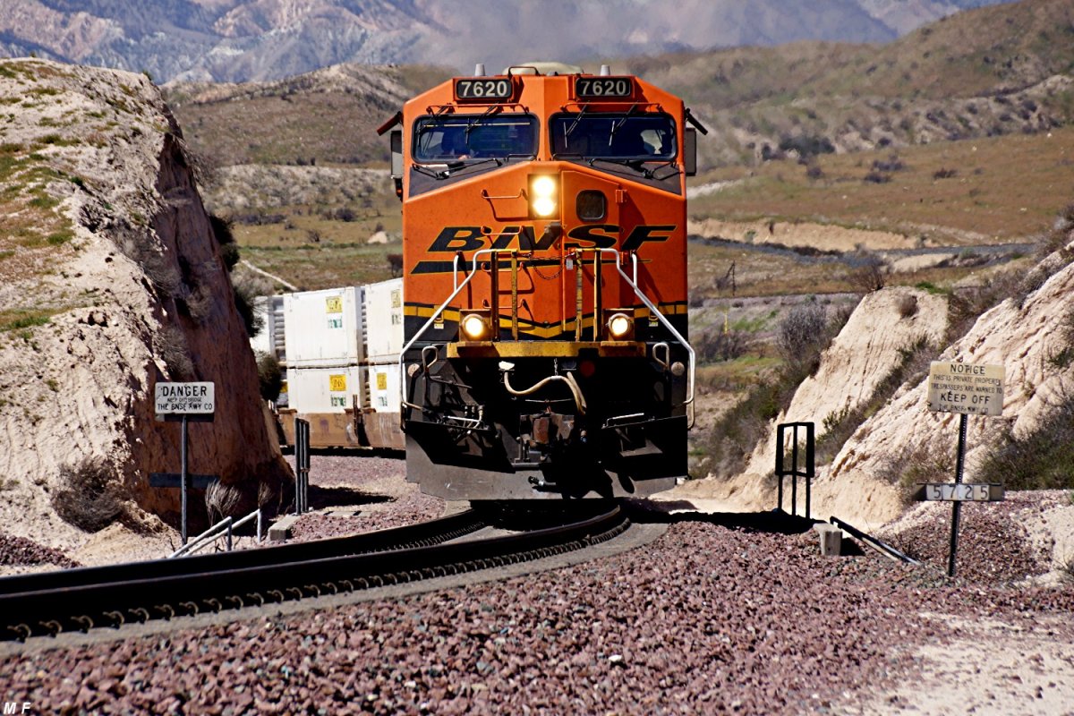
MF 3/24/17 BNSF 7620 is EB on BNSF MT-3 . . .
- 071 |
MF 3/24/17 . . . @ USFS 3N45 near WSI -
072 |
 |
 |
|
MF 3/24/17 -
073 |
MF 3/24/17 -
074 |
updated:
April 4, 2017
|
April 2, 2017: Highway 138
(East) Realignment Project. |
|
Marc sends a few of the Summit Overlook Hill
----- (THEN & NOW) MF & GGG |
 |
 |
|
MF 3/22/17
Summit Overlook Hill as of 22 March 17
- 076 |
MF 4/02/17
Summit Overlook Hill as of 02 April 17
- 077 |
 |
 |
|
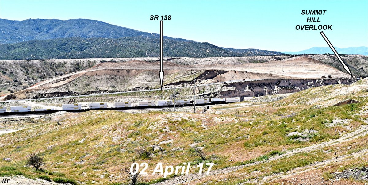
MF 4/02/17
East end of the Hill as of 2 April 17
- 078 |
MF 4/02/17
West end of the Hill as of 2 April 17
- 079 |
 |
 |
|
MF 4/02/17 Two views
of the NEAR FINAL grade . . . .
- 080 |
MF 4/02/17
. . . between Summit Curve and Bridge #3
- 081 |
Yes, Highway 138 is open for
traffic, again!
|
April 9, 2017: Highway 138
(East) Realignment Project. |
|
This morning was cloudy & chilly in the Cajon
but, it being a Sunday, there were no huge machines working and traffic was
very light on SR 138. So, it was a good day to work on some 'THEN & NOW'
pictures. GGG & LMG |
 |
 |
GGG 3/20/17 Summit Overlook Hill on 20 March
from Post Office Rd
-
082 |
GGG 4/09/17 Summit Overlook Hill today 04
April from Post Office Rd
-
083 |
 |
 |
LMG 4/09/17 The earth moving fleet at rest
from the Summit Overlook
-
084 |
LMG 4/09/17 The earth moving fleet at rest
from the Summit Overlook
- 085 |
 |
 |
|
GGG 3/20/17
- 086 |
GGG 4/09/17
- 087 |
|
#086 & #087: As reported before, the VERY low
areas between the piers of the three new bridges will be built up so that
said bridges may be built on solid ground - thus eliminating the need for
very expensive supporting structures. Obviously, the terrain will be
returned to its normal contours post construction. Bridge #3 piers on 20
March and almost buried today. |
|
Highway 138 (East)
Realignment Project - Special Infos |
I have been asked, several times, why this very
expensive road project is necessary. State Rd (SR) 138, both East & West of
I-15, has long been known as "BLOOD ALLEY" for it's numerous accidents and
fatalities.
I found a YOU TUBE motorcycle video of the drive between Cajon Summit
down to I-15. While the drive does not look that bad, remember that SR-138
is very narrow with no escape shoulders and numerous "blind" switchbacks.
Add in the large number of motor homes & vehicles towing boat trailors to
our mountain lakes & parks, and the recipe for disaster is complete.
There is a plan to build 13,000+ homes in Cajon Summit Valley --- just East
of the Railroad Summit.
Also, remember that most CA drivers observe a minimum speed limit of 70 MPH
(on any road) - and bad weather (such a Cajon often sees) means
GO FASTER!
GGG
OH, BTW Booze is cheap and POT is
now legal in CA. GGG
Enjoy the old Hwy 138 from Summit overlook toward I-15:
https://www.youtube.com/watch?v=TlbuUiyDugo |
More Infos about Highway 138:
http://www.aaroads.com/california/ca-138.html
(just click on the first photo w/Josua Trees) |
updated: April 29, 2017
|
April 26, 2017: Highway 138
(East) Realignment Project - Summit |
|
For the last week, SoCal weather has been
dismal with low clouds, 50 MPH winds, dust storms and the beginnings of fire
season. On 26 April, our friend Keith Schreiber visited SR 138 / Cajon
Summit to photograph progress of the realignment. Keith sends the following.
KAS & GGG |
 |
 |
|
KAS 4/26/17 From BNSF Summit looking up at
the SR 138 Summit Overlook -
088 |
KAS 4/26/17 From BNSF Summit looking up at
the SR 138 Summit Overlook -
089 |
 |
 |
KAS 4/26/17 What's left of Summit Overlook
Hill from WEST SR 138
- 090 |
KAS 4/26/17 View of Summit Overlook Hill from
SR 138 Overlook with equipment -
091 |
 |
 |
|
KAS 4/26/17 Another view of Summit Overlook
Hill from SR 138 Overlook -
092 |
KAS 4/26/17 Looking West from W. Summit
Overlook -- toward new Bridge #3 -
093 |
|
On 27 April, Laura, Marc & I drove down to
Ontario via I-15. On our return (uphill) trip, with MAD MARC driving 75 MPH
into a 50 MPH dust storm headwind, I was able to grab these shots looking
toward SR-138 Summit some 2.5 miles East. GGG |
 |
 |
|
GGG 4/27/17 Above BNSF Silverwood and the
Summit Curve is the existing SR 138 Summit Overlook (vehicle parked) and a
view of the "excavation" of Summit Hill -
094 |
GGG 4/27/17 If you trace, left to right,
across the bottom third of the picture, UP NB to Palmdale, the Silverwood
Connector, BNSF #1 & #2, WSI, BNSF MT #3 -
095 |
updated: May 3, 2017
|
May 1, 2017: Highway 138
(East) Realignment Project - Summit and USFS 3N45 |
|
Was up on the summit yesterday and I
must say that they are really making progress. In some areas the dirt
removal is below the 138. Won't be long and that road will be no more as we
know it. I also took some pictures of our train watching spot that so many
of us have enjoyed over the years. Great location.
KAS
|
 |
 |
|
KAS 5/01/17 From Cajon (Hwy 138) Summit /
Summit overlook --- looking WB -
096 |
KAS 5/01/17 From Cajon (Hwy 138) Summit /
Summit overlook --- looking WB w/BNSF Summit Curve -
097 |
 |
 |
|
KAS 5/01/17 Cajon Summit Hill excavation from
SR 138 - 098 |
KAS 5/01/17 Cajon Summit Hill excavation from
SR 138 - 099 |
 |
 |
|
KAS 5/01/17 Cajon Summit Hill excavation from
SR 138 - 100 |
KAS 5/01/17 Looking NE with P.O. Rd heading
up (on the left) to BNSF Cajon Summit --- & SR 138 (between the far
machines) heading toward Hesperia and the Mountain Lakes. If our contractor
sources are correct, Keith's photographic location will be reduced to the
same level of SR 138 in the distance. -
101 |
|
#102 & #103: US Forest Service 3N45 is the
old road going uphill from the existing SR 138 NORTH past the new SR 138,
WSI, under BNSF 3,2 & 1 and over the UP Palmdale Cutoff --- eventually
ending at the OLD (and fire destroyed) Summit Inn at I-15 SUMMIT. Keith's
pictures were taken from the soon to be abandoned section of 3N45 between
the old and new USFS 3N45's ---- looking North (UPHILL) across the new SR
138. This intersection must be redesigned since the new SR 138 will be a 55
MPH Highway. KAS / GGG |
 |
 |
|
KAS 5/02/17 -
102 |
KAS 5/02/17 -
103 |
|
May 6, 2017: Highway 138
(East) Realignment Project - "Hauling out 657 scrapers" |
|
These are the scrapers used on the 138
alignment project - being hauled off to another earth moving
project. In other words, guess they're finished with the major earth
movements on the SR 138 project. Also nice to see, how these huge trucks are
rolling over the temporary pavement connecting old SR 138 section. In the
backround we can even see a BNSF EB intermodal train. |
|
Great film
with drone taken by
SoCalEarthMovers (3'52"):
https://youtu.be/oXvXmxTHAxk |
|
May 8, 2017: Highway 138
(East) Realignment Project (20 % complete) |
Excellent footage of construction incl. many
views from drone by Caltrans.
Be sure to follow us for more real time
updates: Caltrans District 8:
www.caltrans8.info |
|
Video by Caltrans District 8
(2'20"):
https://www.youtube.com/watch?v=85UhgSd5VAQ
|
updated: May 20, 2017
|
May 10, 2017: Highway 138
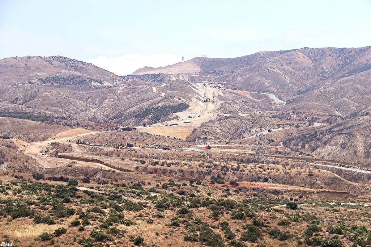
(East) Realignment Project - as seen from Hill 582 |
Here are a few of the Hwy 138 project
from Hill 582
when Spike and I (Bruce "Doc" Jones) were there on May 10.
It shows a different more general perspective of where the road is going to
go.
Note the bridge construction and the path of the old Hwy 138 up the hill
toward the Summit Overlook.
It seems to me the Summit
Overlook might survive so long as some of the old road survives. Any
thoughts on that? Doc Jones |
 |
 |
|
BHJ 5/10/17 Looking toward Summit -
110 |
BHJ 5/10/17 In the foreground is BNSF MT-3 -
111 |
 |
 |
|
BHJ 5/10/17 closer view -
112 |
BHJ 5/10/17 Bridge construction is visible -
113 |
updated: May 20, 2017
|
May 19, 2017: Highway 138
(East) Realignment Project - Summit |
Keith Schreiber visited the SR 138 Cajon
Summit area yesterday and sends the following -
THANKS KEITH
- KAS & GGG
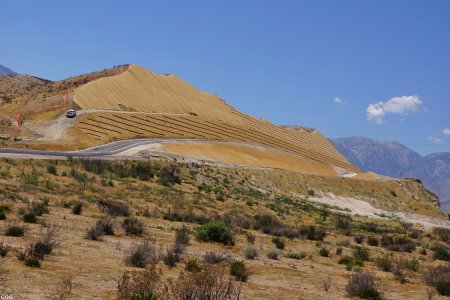
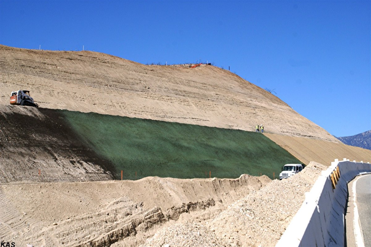
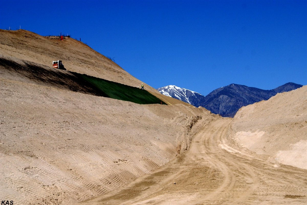
#104-105: Looking across SR 138, from the
Cajon Summit Observation area, the double terracing of the Summit Hill can
be seen. The crews are installing a green mesh, probably infused with the
seeds of native desert plants, to battle the inevitable future erosion.
|
 |
 |
|
KAS 5/19/17 -
104 |
KAS 5/19/17 closer view from K-Rails -
105 |
 |
 |
|
#106-108: With the existing SR 138 on the
upper right, it APPEARS ??? the new SR 138 alignment will be BETWEEN the old
SR 138 Road /Summit Observation area and Summit Hill. |
|
KAS 5/19/17 -
106 |
KAS 5/19/17 -
107 |
 |
 |
|
KAS 5/19/17 -
108 |
KAS 5/19/17 Detailed view of Summit Hill -
109 |
updated: May 30, 2017
|
May 28, 2017: Highway 138
(East) Realignment Project |
Last SUNDAY (5/28/17), Marc & I decided to do
a an in-depth trip to document progress on the SR-138 realignment project.
With MAD MARC driving, I never know where I will wind up --- but it's always
a fun adventure!!! Being a Sunday and a NON-work day, we were somewhat
confident about not being flattened by some HUGE earth mover.
Also, as previously mentioned, the areas
between the very tall bridge abutments and piers have been filled-in so that
the bridge 'false work' and later concrete pouring may be accomplished on
solid ground --- with the normal terrain to be restored later. GGG &
MF |
|
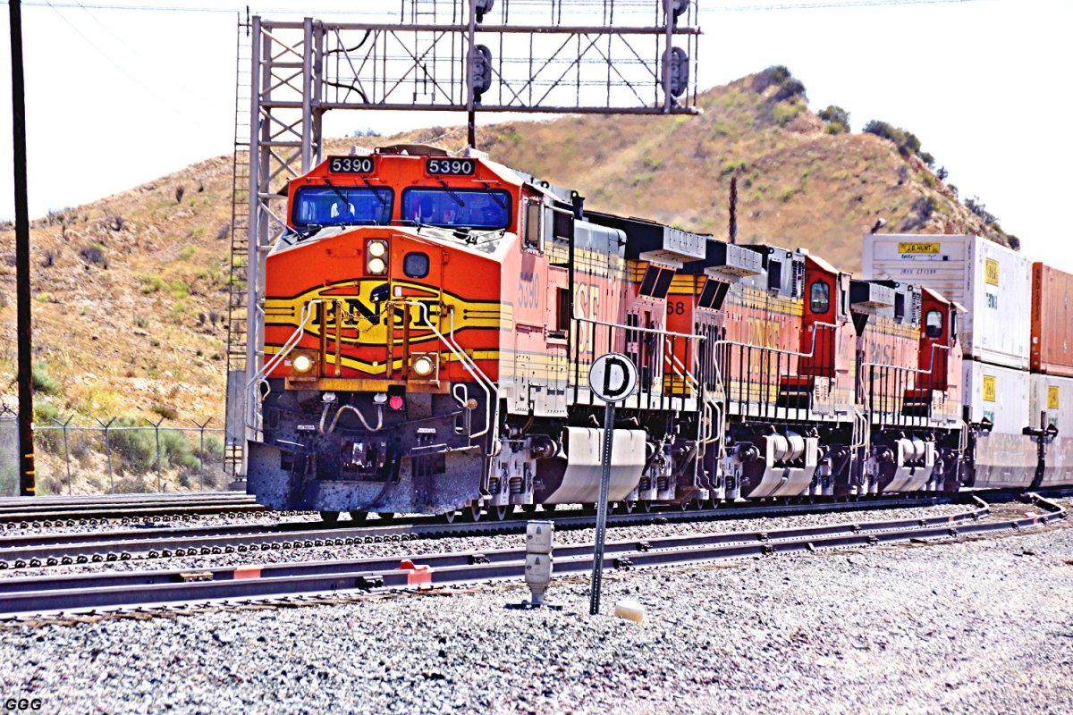
#114 & #115 Using the UPRR / USFS road from
Oak Hills to Summit, we caught BNSF 5390 WB heading down the hill.
|
 |
 |
|
GGG 5/28/17 BNSF 5390 WB on MT-3 at Summit -
114 |
GGG 5/28/17 same BNSF intermodal leaving
Summit - 115 |
 |
 |
|
GGG 5/28/17 From Post Office Rd, the Summit
Hill is pictured. The brown material on terrace #2 is burlap placed to
protect the green HYDROSEED sprayed to prevent erosion. -
116 |
GGG 5/28/17 From the Eastern base of Summit
Hill, the Hill & SR-138 (to the right) can be seen. -
117 |
 |
 |
|
GGG 5/28/17 From the Summit Overlook area
looking West, the new alignment & the BNSF Summit Curve. -
118 |
GGG 5/28/17 BNSF 5998 EB passes
Hill 582
(left)- 119 |
 |
 |
|
GGG 5/28/17 BNSF 5998 EB climbs to Summit
Curve - 120 |
GGG 5/28/17 BNSF 5998 EB rounds Summit Curve
into Summit - 121 |
|
#122 & #123 Bridge #2 looking West. We have
been asked why we take no pictures of bridges #1 or #2. After an
"INTERESTING" MAD MARC DEMOLITION DERBY DRIVE
(on what's left of Pipeline Road), we could finally see the Bridge #2 area.
Obviously, we normally can't use the one construction access road from
SR-138 nor the new alignment thus making photography of Bridges #1 & #2
near impossible. |
 |
 |
|
GGG 5/28/17 Bridge #2 -
122 |
GGG 5/28/17 Bridge #2 (to be built) -
123 |
 |
 |
GGG 5/28/17 Bridge #3, looking East, from the
new SR-138 alignment.
124 |
GGG 5/28/17 Bridge #3, looking East, from the
new SR-138 alignment.
125 |
 |
 |
|
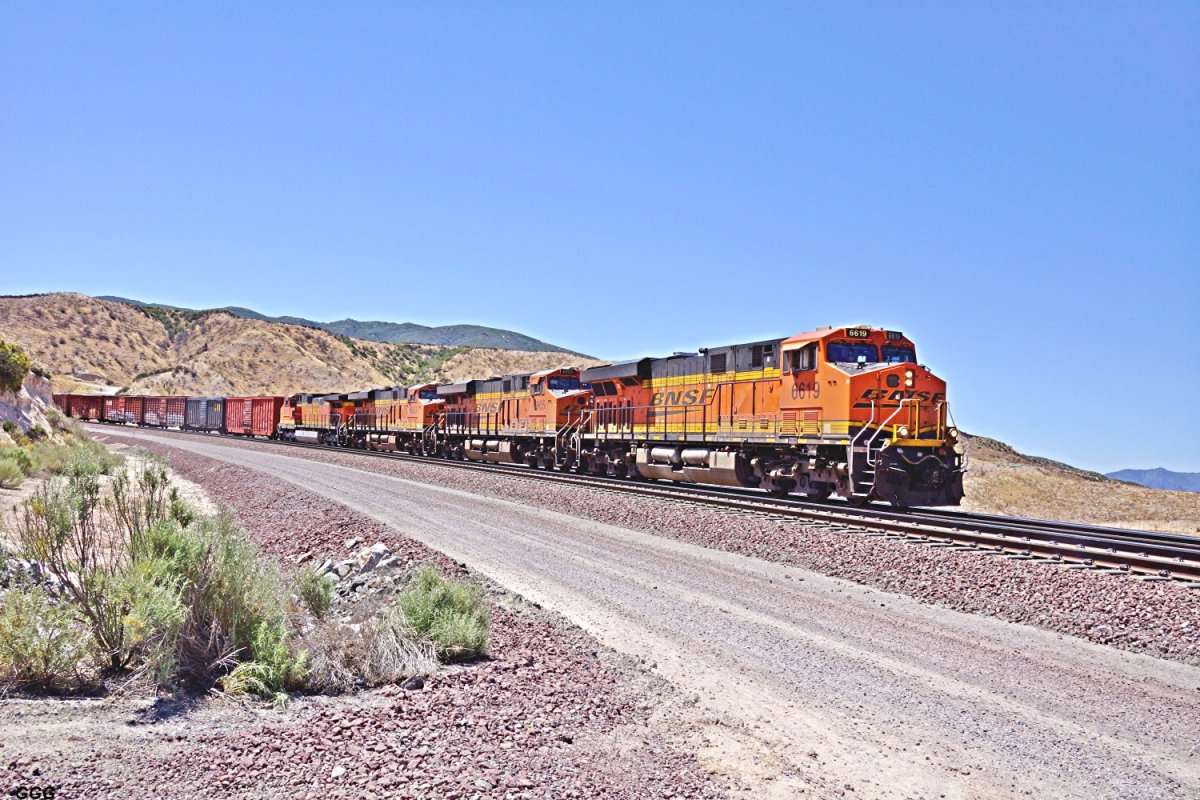
GGG 5/28/17
From INSIDE the Summit
Curve BNSF 6619 is WB. -
126 |
GGG 5/28/17 UP 4783 East climbs toward the
Summit Curve. - 127 |
updated: July 1, 2017
|
June 27-29, 2017: Highway 138
(East) Realignment Project |
|
As most know, Bob Widholm (San Diego) often
drives his motor home up here - to spend a long weekend on West Summit
Island. Paul Westover (CA City - North of Edwards AFB) visited Bob and,
while in the area, took the following images of the SR-138 realignment.
PW / GGG |
From the West end of the summit Outlook:
#128: From Right to Left---The new
TEMPORARY SR 138, "K rails", the OLD 138 and the OLD
Summit Observation area.
We UNDERSTAND the area left of the "K rails" will be
lowered to near track level and will hold the FINAL
SR-138 alignment ???? |
 |
 |
|
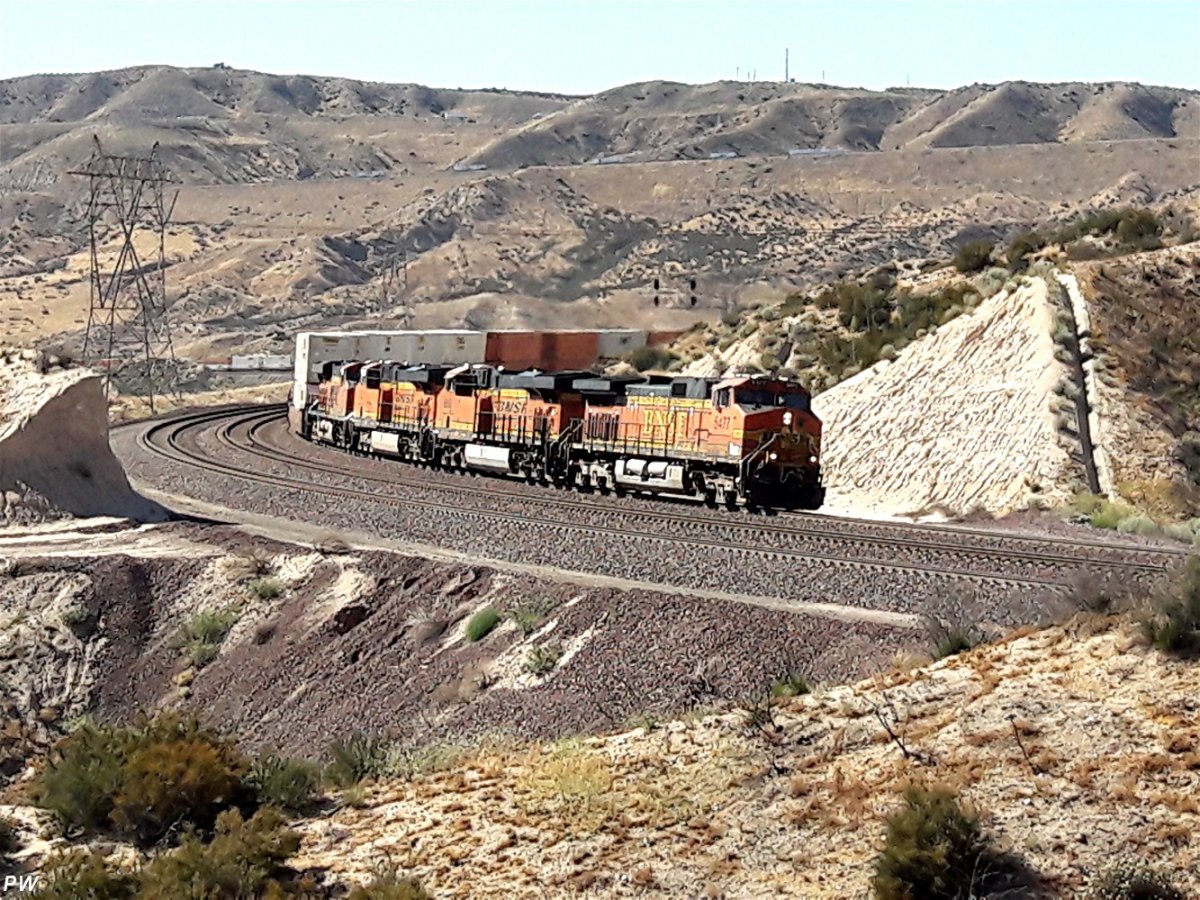
PW 6/27/17 new temporary SR 138 above Summit
- 128 |
PW 6/27/17 BNSF 5473 EB enters the Summit
curve - 129 |
|
From 3N45 / BR- #3 |
 |
 |
|
PW 6/27/17 an image of WSI with Bob's
Motorhome - 130 |
PW 6/27/17 Bridge # 3 under construction -
131 |
 |
 |
|
PW 6/27/17 Bridge # 3 under construction -
132 |
PW 6/27/17 I'm told that Paul "let Bob outta
his cage for this picture"
- 133 |
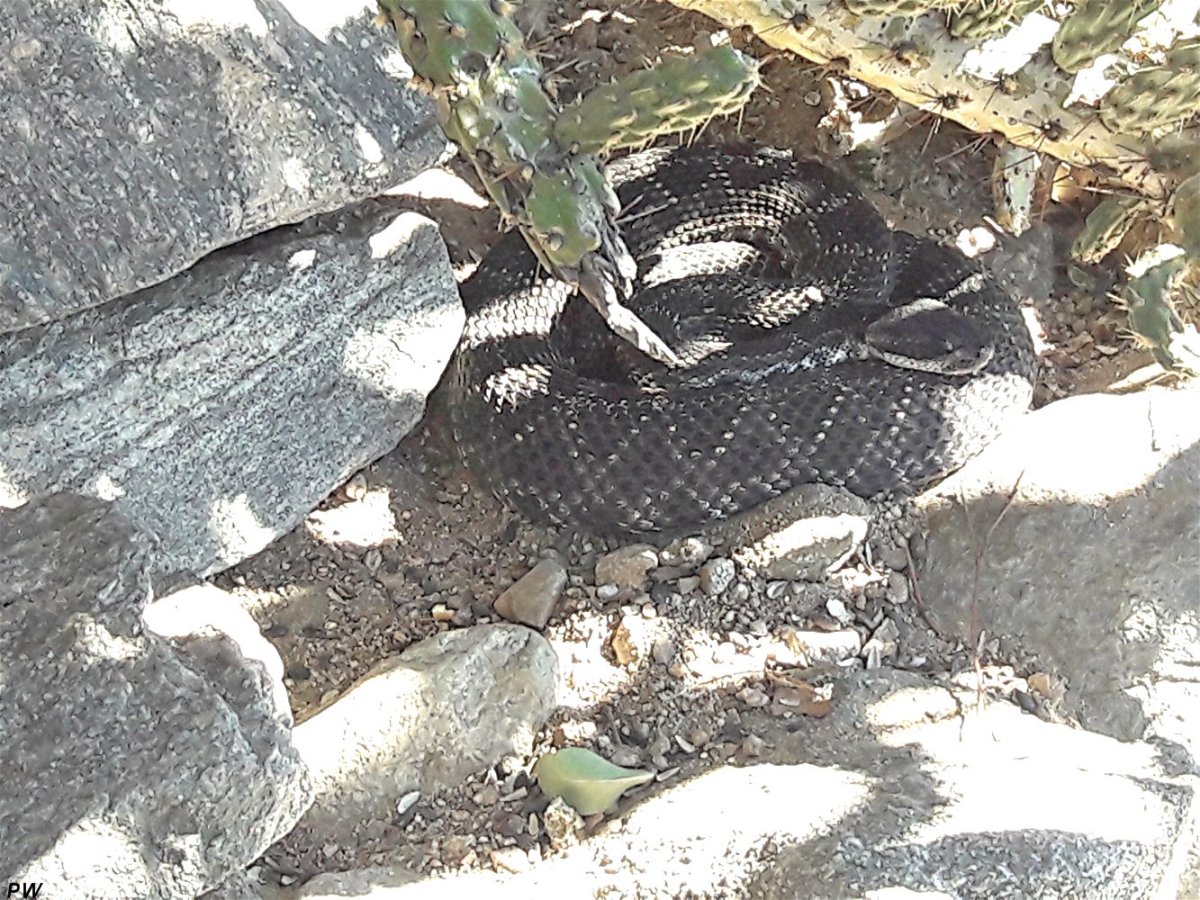
From the second day of their visit to WSI,
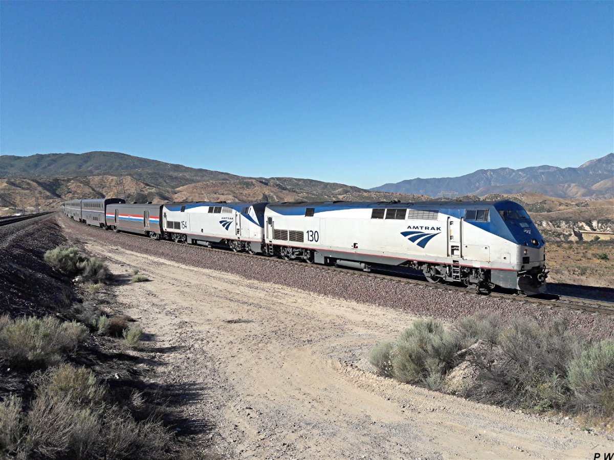
Bob & Paul send the following:
#134: BNSF 3816 leads a very late AMT #3
West, past West Summit Island.
#135: After joining DET on Hill 582, the
trio found Robby the Rattler #XX. Realizing the these VARMINTS are protected
by the State of California, they PROPERLY cared for & removed the creature
from the Hill. PW / GGG |
 |
 |
|
PW 6/28/17 Delayed AMT #3 WB past WSI -
134 |
PW 6/28/17 Robby the Rattler on Hill 582 -
135 |
|
Second Addition to HIGHWAY 138 REALIGNMENT above
- Images by Paul Westover 06-29-17 |
 |
 |
|
PW 6/29/17 A new culvert is placed near
Bridge #3 - 136 |
PW 6/29/17 BNSF 8035 WB @ WSI on MT-2 -
139 |
 |
 |
|
PW 6/29/17 UP 1996 is WB @ WSI -
137 |
PW 6/29/17 AmTrak #3 WB @ WSI on MT-3 -
138 |
 |
 |
|
PW 6/29/17 BNSF 8175 EB and above UP NB on
UPT - 140 |
PW 6/29/17 BNSF LIGHT POWER move WB MT-3 @
WSI - 141 |
 |
 |
|
PW 6/29/17 Bridge #3 as of 06-29-17 -
142 |
PW 6/29/17 UP HI-RAIL on Silverwood Connector
- 143 |
 |
 |
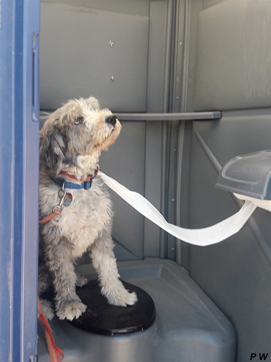
PW 6/29/17 JAZZ (the WONDER DOG) saving the
Mojave environment
- 144 |
PW 6/29/17 Late afternoon UP 9027 EB on MT-1
@ WSI - 145 |
updated: July 18, 2017
|
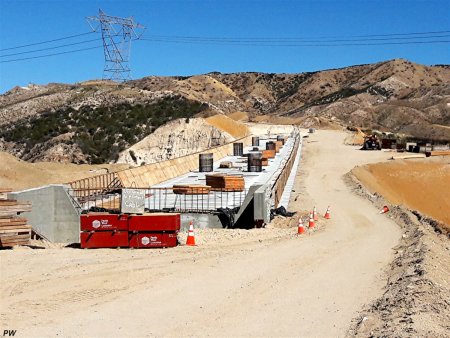
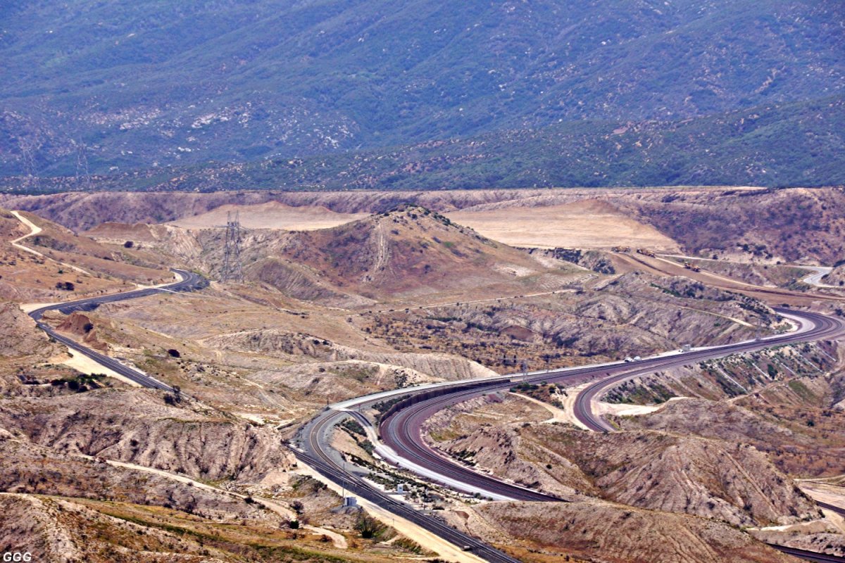
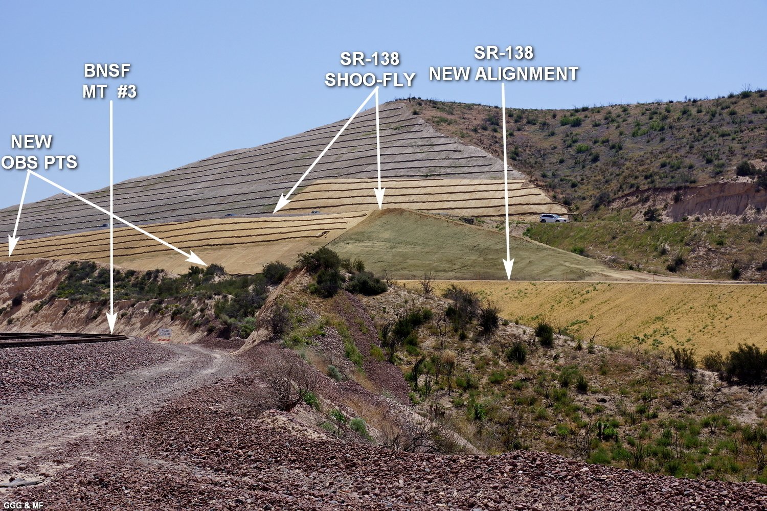
July 16, 2017: Highway 138
(East) Realignment Project - Summit |
Yesterday (07-16-17) was HOT, HUMID (for
here), and SMOKEY (from all of the CA fires). However Marc & I braved??? the
Cajon weather to collect the attached.
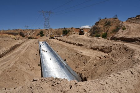
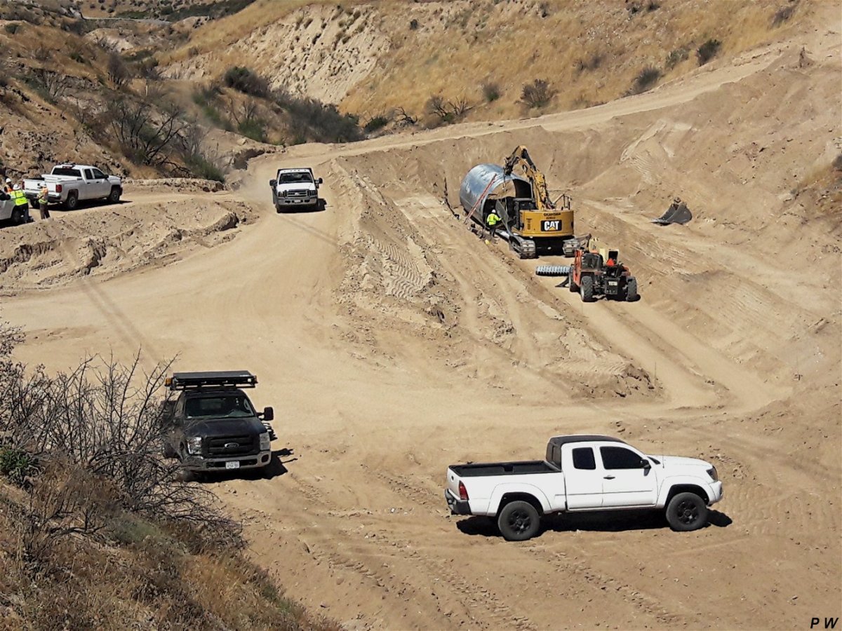
# 146: The contractor has built an SHOO FLY to allow realignment of SR-138
to continue. Between the OLD & NEW 138 alignments, a trench is being dug
which will hold the SR-138 final alignment. The asphalt has been removed
from the old 138. It is unknown, to us, exactly what the fate of the old
Summit overlook will be.
# 147: From the East end of Summit Hill, the new temporary & old SR-138
alignments are visible. |
 |
 |
|
GGG 7/16/17 -
146 |
GGG 7/16/17 -
147 |
 |
 |
|
GGG 7/16/17
03 Driving WB on the Shoo FLY
- 148 |
GGG 7/16/17
From the East end of Summit Hill, looking
West toward Bridge #3---with Hill 582 visible in the background.
-
149 |
 |
 |
|
GGG 7/16/17
Looking West at the East end of BR - #3. A
few degrees of "superelevation" (tilt) was built into the bridge - which
will lead into a road turn just behind the camera.
- 150 |
GGG 7/16/17
The West end of BR - #3 with the
aforementioned road curve visible.
- 151 |
 |
 |
|
GGG 7/16/17
Marc took this image showing how much higher
Bridge #3 is, above the old SR-138 alignment.
- 152 |
GGG 7/16/17
Looking West at Bridge #2
- 153 |
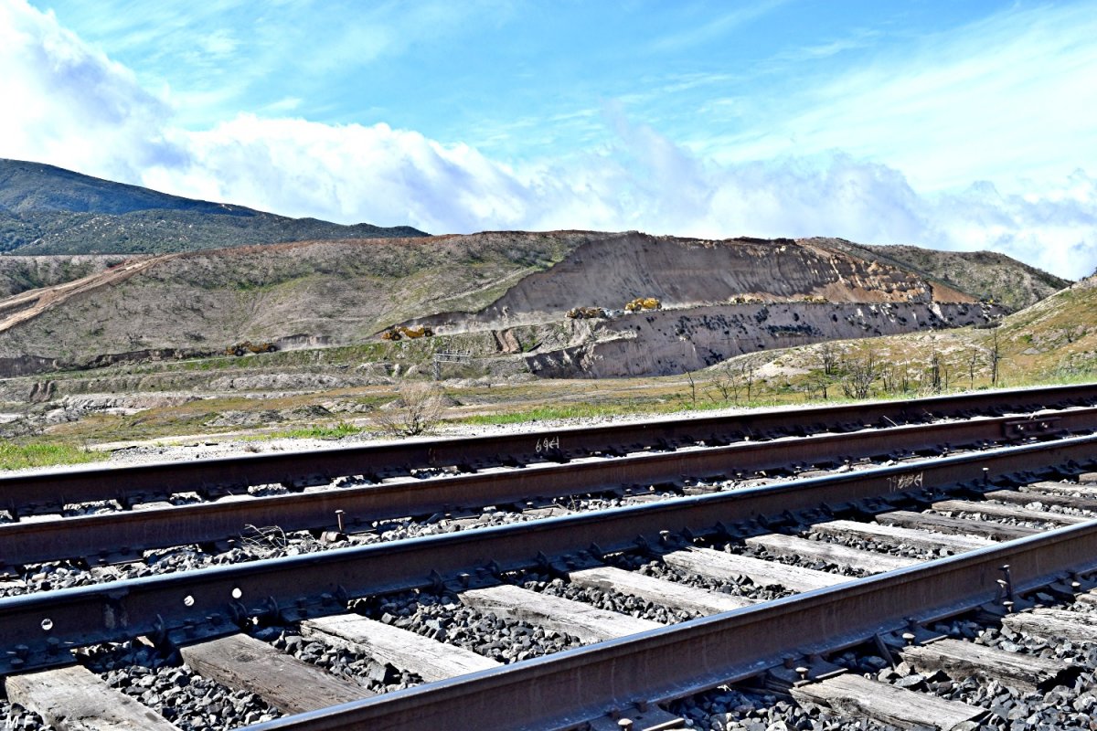
FROM HILL 582
DET & his helpers are doing a SUPER job of tending Hill 582 during our
severe long-term heat wave---The Hill NEVER LOOKED BETTER |
 |
 |
|
GGG 7/16/17
A view of BR - #3 showing the bridge's
"superelevation" & the road curve
- 154 |
GGG 7/16/17
From BR - #3 to Summit
- 155 |
updated: August 10, 2017
|
early August, 2017:
Highway 138 (East) Realignment Project by
Ruedi Schai, Switzerland |
 |
 |
|
RUS Summit Hill was cut down and got a temp.
road - 3081 |
RUS in 2018 this will be new Hwy 138 -
3085 |
 |
 |
|
RUS left = new Hwy next to BNSF tracks -
3086 |
RUS the
West end of BR - #3 -
3087 |
 |
 |
|
RUS - 3255 |
RUS - 3256 |
 |
 |
|
RUS - 3258 |
RUS - 3260 |
 |
 |
|
RUS - 3261 |
RUS
The West end of BR - #3
- 3263 |
 |
 |
|
RUS BNSF WB leaving Summit -
3266 |
RUS same BNSF WB on Summit Curve toward WSI -
3267 |
 |
 |
|
RUS - 3265 |
RUS temp. Summit detour road of Hwy 138 -
3269 |
 |
 |
|
RUS at left is BNSF Summit cut -
3359 |
RUS - 3365 |
updated: August 20, 2017
|
August 18, 2017: Highway 138
(East) Realignment Project |
Marc & I visited DET on Hill 582 yesterday
(Friday). We also checked out the SR 138 realignment project, but found
little progress to report.
# 156: Nothing much has changed on Summit
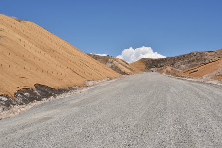
Hill, except for the installation of even more "wattles" to control erosion.
The Summit observation point is untouched --- so far. GGG & MF |
 |
 |
|
GGG 8/18/17 Summit Hill -
156 |
GGG 8/18/17 More forms being placed for
Bridge #3 - 157 |
 |
 |
|
GGG 8/18/17 More forms being placed for
Bridge #3 - 158 |
GGG 8/18/17 Just West of Bridge #3, a 12 foot
culvert was built 'on-site', to carry creek water under the new SR-138.
- 159 |
updated: September 21, 2017
|
September 13, 2017: Highway 138
(East) Realignment Project |
A while back, Bob Widholm (San Diego) camped
on West Summit Island for several days. He was joined by Paul Westover
(California City) and Lois M. (Hemet) ----- together, they explored the SR
138 Realignment Project.
Current contractor efforts appear
to be centered on finishing the three bridges.
# 160: Something seldom seen on Cajon --- a “dirty (contaminated) dirt”
train headed East --- Taken from near WSI with the Silverwood Connector on
the left & BNSF MT #3 on the right.
Paul Westover Photography - GGG |
 |
 |
|
PW 9/11/17 Dirt Train pass WSI -
160 |
PW 9/13/17 Bridge #2 -
161 |
 |
 |
|
PW 9/13/17 Bridge #3 -
162 |
PW 9/13/17 Bridge #3 -
163 |
updated: October 3, 2017
|
September 30, 2017: Highway 138
(East) Realignment Project |
|
No huge news to report on the project.
However, the concrete deck for Bridge #3 is more than 50% poured and is
covered with plastic to slow the curing reaction. # 168: Summit Hill: We
hope the area in the middle of this image (where the dirt has been
disturbed) will be the new highway alignment and that the old Observation
Point will remain untouched. And a few trains in poor light. GGG |
-GGG-09-30-17X.jpg) |
-GGG-09-30-17X.jpg) |
|
GGG 9/30/17 Bridge #3 from Hill 582 ---
- 164 |
GGG 9/30/17 Bridge #3 --- looking East toward
Cajon Summit. - 165 |
-GGG-09-30-17X.jpg) |
-GGG-09-30-17X.jpg) |
|
GGG 9/30/17 Bridge #3 from Hill 582 -
166 |
GGG 9/30/17 Bridge #3 from the 3N45 Junction
- 167 |
-GGG-09-30-17X.jpg) |
-GGG-09-30-17X.jpg) |
|
GGG 9/30/17 Summit Hill -
168 |
GGG 9/30/17 BNSF 4661 is WB at Hill 582 -
169 |
-GGG-09-30-17X.jpg) |
-GGG-09-30-17X.jpg) |
|
GGG 9/30/17 BNSF DPU is WB at Hill 582 -
170 |
GGG 9/30/17 UP 8080 is WB on MT #3 below Hill
582 - 171 |
-GGG-09-30-17X.jpg) |
-GGG-09-30-17X.jpg) |
|
GGG 9/30/17 Just behind the power is the
newest ArroWedge - 172 |
GGG 9/30/17 this is the newest design of
ArroWedge - 173 |
|
Newest design of ArroWedge:
https://www.uprr.com/newsinfo/releases/environment/2013/0903_arrowedge.shtml
|
updated: October
26, 2017
|
October 18, 2017: Highway 138
(East) Realignment Project |
|
Doc Jones sends the following of the SR-138
realignment. BHJ |
 |
 |
|
BHJ 10/18/17 The near completed BR #3 from
Hill 582 - 174 |
BHJ 10/18/17 BR #3 from Hill 582 (w/MT-3 in
the foreground) - 175 |
 |
 |
|
BHJ 10/18/17 The SR 138 Summit Bypass from
BNSF Track Level - 176 |
BHJ 10/18/17 left Bypass, right old 138
w/overlook - 177 |
 |
 |
|
BHJ 10/18/17 The SR 138 Summit Bypass from
Post Office Rd - 178 |
BHJ 10/18/17 The SR 138 Summit Bypass from
Post Office Rd - 179 |
updated:
January 26, 2018
|
January 26, 2018: Highway 138
(East) Realignment Project |
Excellent footage of the construction of a
concrete bridge by Caltrans.
Be sure to follow us for more real time
updates: Caltrans District 8:
www.caltrans8.info |
|
Video by Caltrans District 8
(1'16"):
https://www.youtube.com/watch?v=o5s6v3RTL8U
|
|
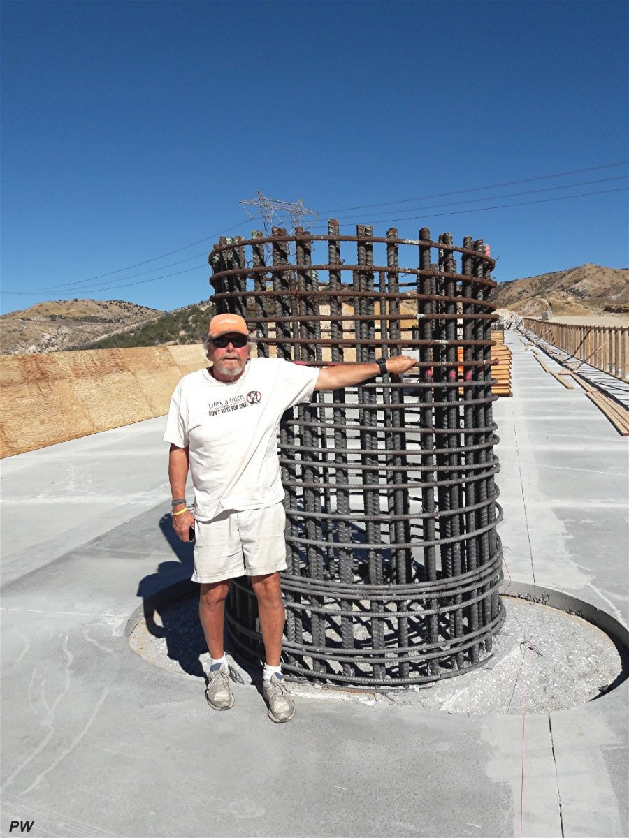
These photos are corresponding to the video
about bridge # 1 construction applying concrete. |
 |
 |
|
concrete pouring process -
180 |
concrete pouring process -
181 |
 |
 |
|
concrete pouring process closeup -
182 |
part of new Hwy 138 -
183 |
 |
 |
|
bridge # 1 is almost finished w/concrete
pouring - 184 |
great view from above taken with a drone -
185 |
|
6 photos above copyright: California, DOT
(Department of Transportation), Caltrans District 8 |
updated:
March 3, 2018
|
March 3, 2018: Highway 138
(East) Realignment Project / 10 - DAY FULL CLOSURE |
|
SR-138 will be closed between Interstate 15
and Summit Valley Road on Wednesday, March 7th at 6:00 a.m. until Saturday,
March 17th at 6:00 a.m. The closure is necessary to complete pavement
realignment work. |
|
See details -
click here |
 |
updated:
March 7, 2018
|
March 4, 2018: Highway 138
(East) Realignment Project |
|
Last Sunday (03-04-18) Marc & I were able to
access Cajon areas normally unavailable. On 27 Feb, Cajon experienced a
rain/snow storm which caused moderate erosion, especially to the Summit Hill
--- visible in some of the following pictures. GGG & MF |
 |
X.jpg) |
|
GGG 3/04/18 BR #1 Looking West to where the
new alignment will connect to the existing SR 138-near I-15 -
186 |
GGG 3/04/18 Looking West at BRIDGE (BR) #2
(close-up) - 187 |
 |
|
GGG 3/04/18 Looking West at BRIDGE (BR) #2 -
188 |
 |
 |
GGG 3/04/18 Parker Ranch Rd (the normal
access to Hill 582) with Hill 582 in the distance. There have been questions
as to a gate being erected at this spot, however since the USFS has elected
to number the road 3N48, we HOPE that the road will remain open to
the public.
left - 189
right - 190 |
 |
 |
|
GGG 3/04/18 BR #2 from above -
191 |
GGG 3/04/18 BR #3 looking East toward Summit
- 192 |
 |
 |
|
GGG 3/04/18 BR #3 looking West -
193 |
GGG 3/04/18 Looking at Summit from BR #3 -
194 |
 |
 |
|
GGG 3/04/18 Summit from BNSF MT #3 -
195 |
MF 2/27/18 Cajon Summit Hill just after the
02-27-18 storm - 196 |
 |
 |
|
GGG 3/04/18 Cajon Summit Hill erosion as of
today. Just right of the auto, the contractor has begun cutting what we
think will be the new SR-138 summit alignment. -
197 |
GGG 3/04/18 The new cut mentioned in photo
#197 - 198 |
 |
 |
|
GGG 3/04/18 Cajon Summit overlook w/BNSF
Summit - 199 |
GGG 3/04/18 Cajon Summit overlook -- as it
stands now - 200 |
updated:
March 18, 2018
|
March 14, 2018: Highway 138
(East) Realignment Project |
The 10 day closure of SR-138 between I-15 and
Post Office Rd (just East of Cajon Summit) is due to end on 03-17-18. It is
our understanding that the closure was called to allow the contractor to cut
the new SR-138 Summit alignment down to final grade.
On 03-14-18, Marc got as close as
possible and sends the following images:
MF & GGG |
 |
 |
|
MF 3/14/18 BNSF 5075 is EB @ Cajon Summit
-
201 |
MF 3/14/18 Views of the SR-138 realignment
progress - 202 |
 |
 |
|
MF 3/14/18 View of the SR-138 realignment
progress - 203 |
MF 3/14/18 See explanation below -
204 |
|
Photo # 204 Labeled view of the project ---
Evidently the Rd from SR-138 up to the BNSF Summit crossing is no longer
called POST OFFICE Rd or THE SUMMIT TRUCK TRAIL. Also, it APPEARS that the
Summit Overlook area has been preserved (at least for now).
|
 |
 |
|
MF 3/14/18 From across the tracks - looking
East at the Summit Overlook area. -
205 |
MF 3/14/18 UNION PACIFIC-1 and COYOTE-0
(between tracks) -
206 |
|
March 16, 2018:
SR-138 realignment project
closure extended until March 23rd |
SAN BERNARDINO, Calif. (VVNG.com) — The California
Department of Transportation (Caltrans) announced Friday, the full closure
of SR-138 has been extended due to recent rainstorms.
SR-138 will remain closed between Interstate 15 and Summit Valley Road until
Friday, March 23rd at 6:00 p.m., Caltrans officials announced. |
 |
Aerial photo taken March 2018 showing the
current progress of the SR-138 realignment project.
(copyright Victor Valley News and original photographer) -
207 |
updated:
March 25, 2018
|
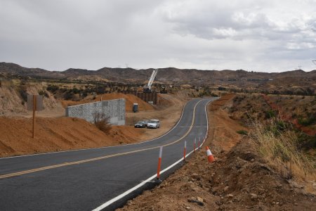
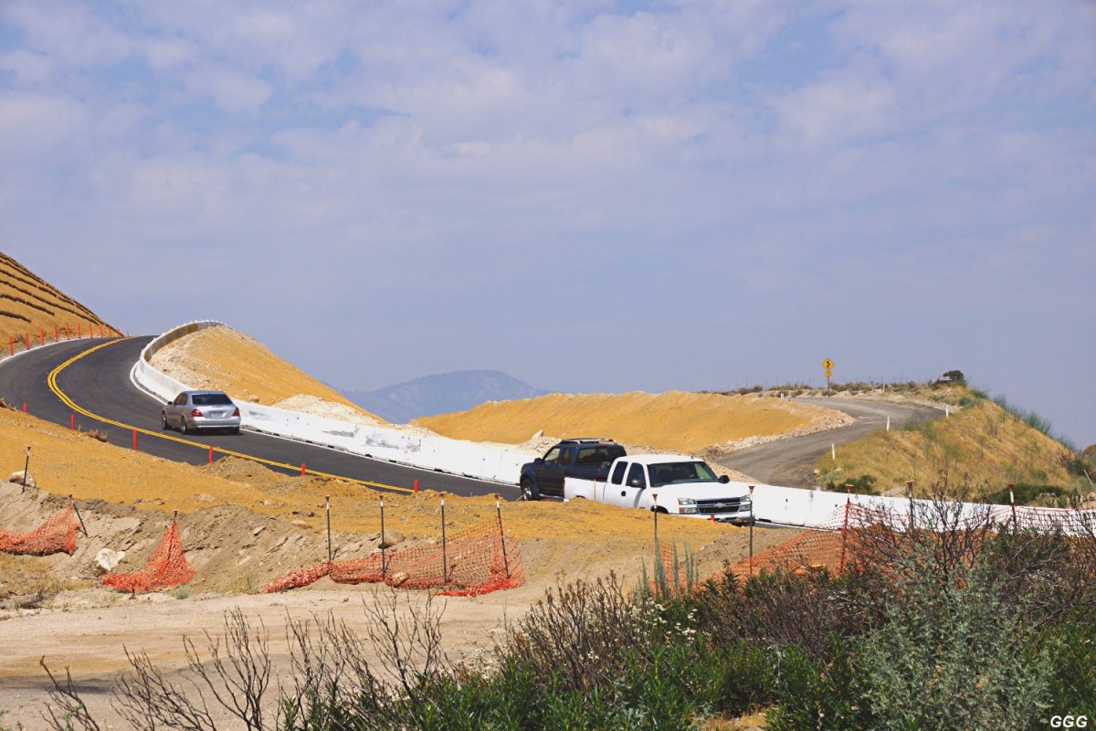
March 24, 2018:
New SR-138 is open for
traffic |
|
Don Toles made a run up to the Hill this morning - new
SR-138 was open and in use but he took Baldy Mesa Rd and the BNSF ROW road
along tracks 1 & 2 to reach the Hill. A few muddy spots along the way, but
only minor storm damage. All was well on the Hill - ground is damp, but the
rainfall must have been light at best. Cold 46 F. and windy. On the way out
he drove to Summit along the SP/UP track and then took the new highway back
down to the Jct. Then he drove back up 138 and took Parker Ranch Rd. from
off the new 138 - wide open, no gate or Road Closed sign. Hope they'll keep
it that way! DET |
 |
Please note: Even most of the realignment road is in
service, there is a section at Summit (red/yellow) not finished, yet!
You, may notice on the video below - as we can see the old part still in use
just below Summit. |
|
March 24, 2018:
New Realignment of SR-138 on
video |
|
Cajon Pass, CA - On Saturday March 24th 2018 Driving
east bound on the NEW Realignment Project on State Route 138 east of
Interstate 15 freeway. The project is located on SR-138 just east of
Interstate 15 to Summit Post Office Road. |
|
Video taken by jgkix on 3/24/18 (5'15"):
https://www.youtube.com/watch?v=HzmbVnCE_vc |
updated:
April 3, 2018
|
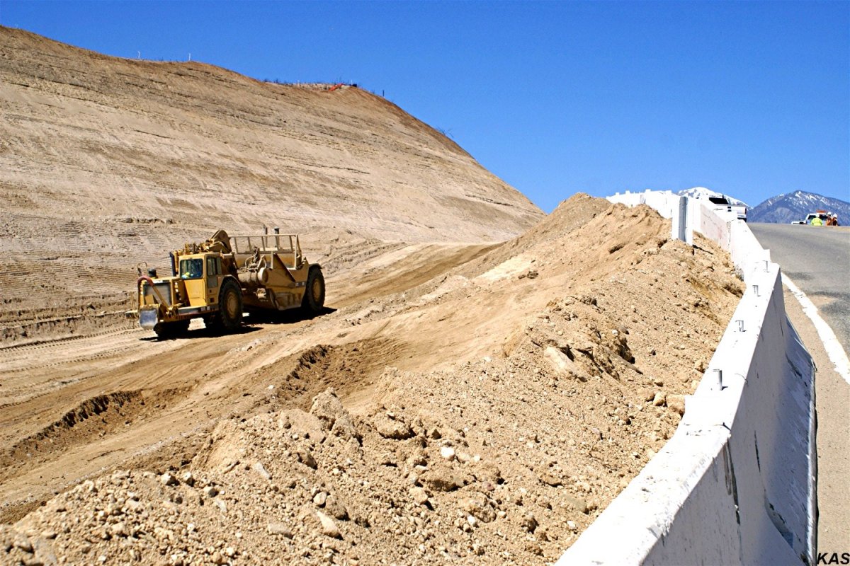
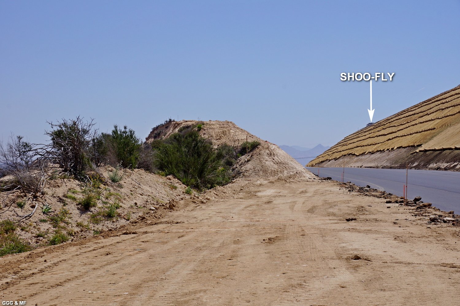
March 31, 2018: Highway 138
(East) Realignment Project |
Friend Keith S. visited Cajon Summit on March
31st and sends the attached.
The new SR-138 is now open between
I-15 and West Summit but traffic is stlll diverted onto the Cajon road
sho-fly to cross over the Summit ---while the contractor lowers the new
Summit Road portion to final grade. KAS - GGG |
 |
 |
|
KAS 3/31/18 It appears that the new SR-138
will be in a canyon. The BNSF tracks are over and well below the Hill on the
right. The OLD Summit Observation Point was high on the right.
-
208 |
KAS 3/31/18 Looking East from West Summit,
what's left of the Summit Observation area is labeled. -
209 |
 |
 |
|
KAS 3/31/18 Summit looking West -
210 |
KAS 3/31/18 at left is new Summit SR-138 -
211 |
|
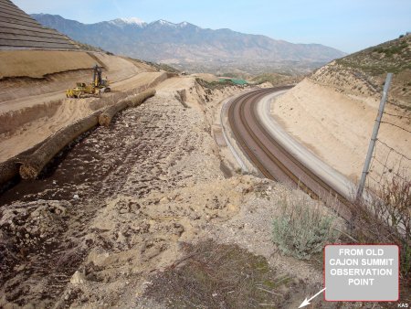
Keith climbed up to the OLD SUMMIT
OBSERVATION Point to photograph the construction --- looking West. Note the
new EYEBROW ditch and fence protecting BNSF track #3.
-- Thanks Keith -
GGG |
updated:
April 17, 2018
|
April 15, 2018: Highway 138
(East) Realignment Project |
On April 15, Marc & I drove into Cajon to
check the progress of the SR-138 realignment. As most know, the new
alignment is open between I-15 and the WEST END of the unfinished SUMMIT
portion of SR-138. So, the temporary Shoo-fly crossing the Summit is still
in use while the contractor finishes the highway.
One of the most frequently asked questions concerned the future of the Cajon
Summit Observation Point, which ONCE overlooked the BNSF Summit Curve and
gave a decent view of much of the Pass. Well, the project has eliminated
most of the West end of the overlook --- which was directly above the Summit
Curve. The little left there is much lower than the old Overlook and,
according to how the safety railings are installed, may be access
restricted.
So, we've added a couple of images
from Keith S. to provide a better view of the area.
GGG, MF, KAS |
 |
 |
|
GGG 4/15/18 From the Eastern base of Summit
hill looking West. While whats left of the Summit overlook looks promising
to photographers, where they place the safety railings will dictate our
access. Also, the remaining overlook hill will be very narrow.
-
212 |
MF 4/15/18 Looking East at the OLD OVERLOOK.
- 213 |
 |
 |
|
KAS 4/15/18 Two from Keith who hiked to the
small summit of the overlook (looking East) -
214 |
KAS 4/15/18 Two from Keith who hiked to the
small summit of the overlook (looking West) -
215 |
 |
 |
|
MF 4/15/18 From the SHOO-FLY traveling West,
the Summit Overlook 'Hill' is pictured -
216 |
MF 4/15/18 From the SHOO-FLY traveling West,
the Summit Overlook 'Hill' is pictured -
217 |
 |
 |
|
MF 4/15/18 From the SHOO-FLY traveling West,
the Summit Overlook 'Hill' is pictured (overview w/Summit Curve) -
218 |
MF 4/15/18 Bridge #3 -
219 |
|
Photos # 219 and 220: Bridge #3 is pictured.
As mentioned, the Canyons were filled in so that the three bridges could be
built on solid ground --- thus eliminating the need for expensive
scaffolding. That fill dirt is now being removed and the land is being
restored to its natural contours. The excess dirt is dumped on the old
SR-138 alignment, which will remain to provide access many HIGH-TENSION
electrical transmission towers in the area. |
 |
 |
|
MF 4/15/18 Bridge #3 (dirt removal) -
220 |
GGG 4/15/18 As of April 15, access to Hill
582 via Parker Ranch Rd, remains open.
-
221 |
 |
 |
|
GGG 4/15/18 Summit Hill from BNSF track level
- 222 |
GGG 4/15/18 Close up w/signal bridge -
223 |
|
Photos # 222 and 223: From the BNSF
Summit tracks --- two views of the Summit Overlook Hill. The actual portion
of the overlook that looked down on the BNSF Summit Curve, appears UNDER &
West of the BNSF cantilever signal. The area, although now much lower,
appears to be wide enough for parking --- if the safety railings allow
access. GGG |
updated: May 1, 2018
|
April 29, 2018: Highway 138
(East) Realignment Project |
|
On April 29, Sunday, Marc & I drove to the
SR-138 realignment project. The unfinished Summit portion of SR-138 is being
paved and the support dirt, under the bridges, is being removed. GGG &
MF |
 |
 |
|
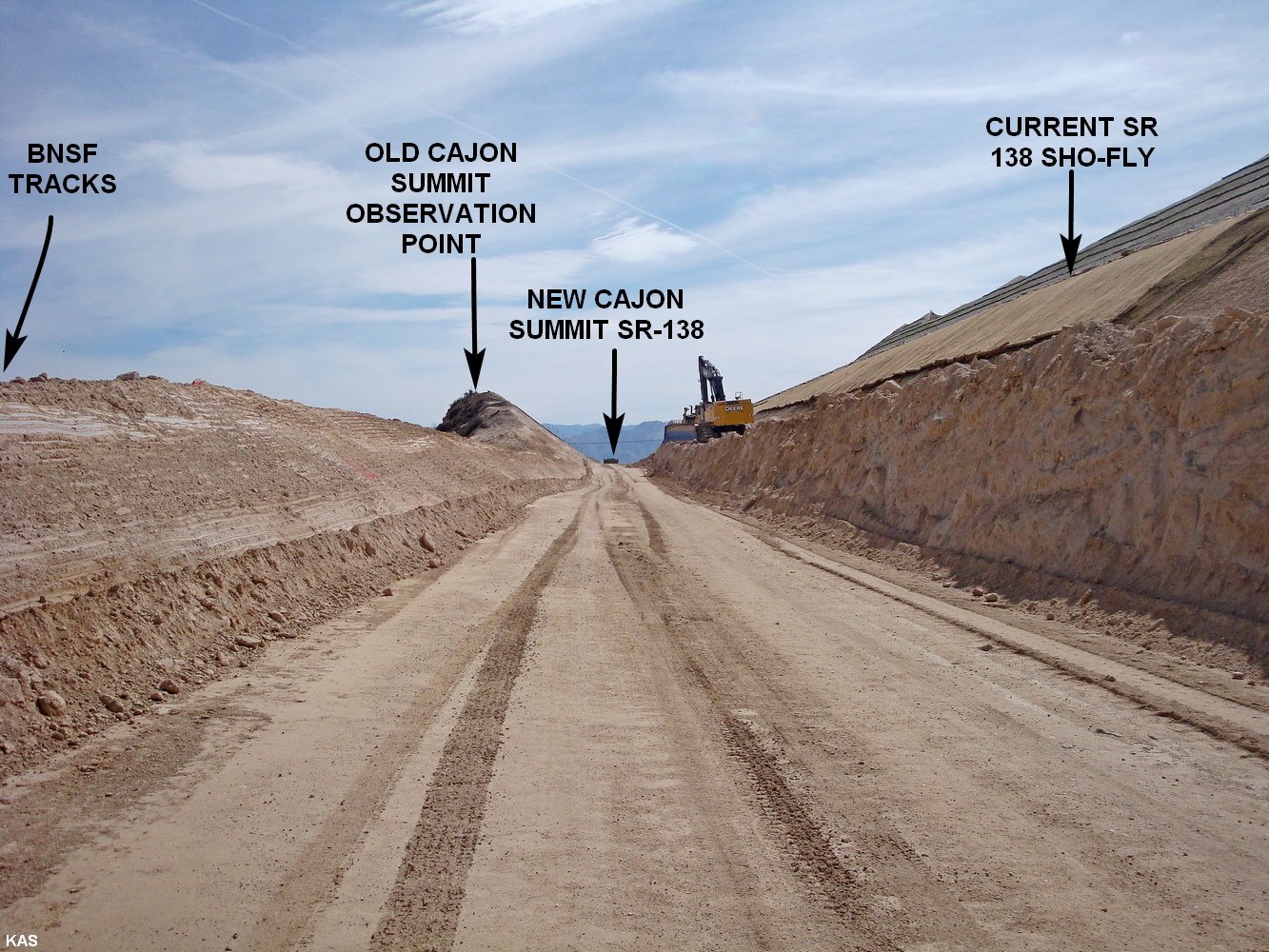
GGG 4/29/18 A labeled picture taken from BNSF
MT #3 at the Summit curve. The OLD SR-138 highway and the OLD Summit
observation point were almost directly above the NEW observation points and
at about the same elevation as the Shoo-fly. So, we estimate that the new
"View" point is 50+ feet lower than before.
-
224 |
GGG 4/29/18 The new and very narrow
Observation point from the new alignment. It is evident that this small area
will need safety railings to keep CA drivers from becoming part BNSF MT-#3
--- and that those railings will probably limit access (especially parking)
to the area.
- 225 |
 |
 |
|
BHJ 3/01/17 14 Months ago, Doc Jones
submitted this picture taken from the OLD and HIGH Observation Point.
-
226 |
GGG 4/29/18 Taken April 29, 2018 from close
to the same horizontal angle ---- a somewhat dramatic change -
227 |
 |
 |
|
GGG 4/29/18 BNSF 6690 is WB on MT #2 @ Summit
curve
-
228 |
GGG 4/29/18 Bridge #3 with the construction
support dirt mostly removed
-
229 |
 |
 |
|
GGG 4/29/18 The dirt removed from under BR #3
is being used to build-up the OLD SR-138 area ---- to the contours existing
before the OLD & ORIGINAL SR-138 was built.
-
230 |
GGG 4/29/18 From Hill 582 - BR #3 up to
Summit. - 231 |
 |
 |
|
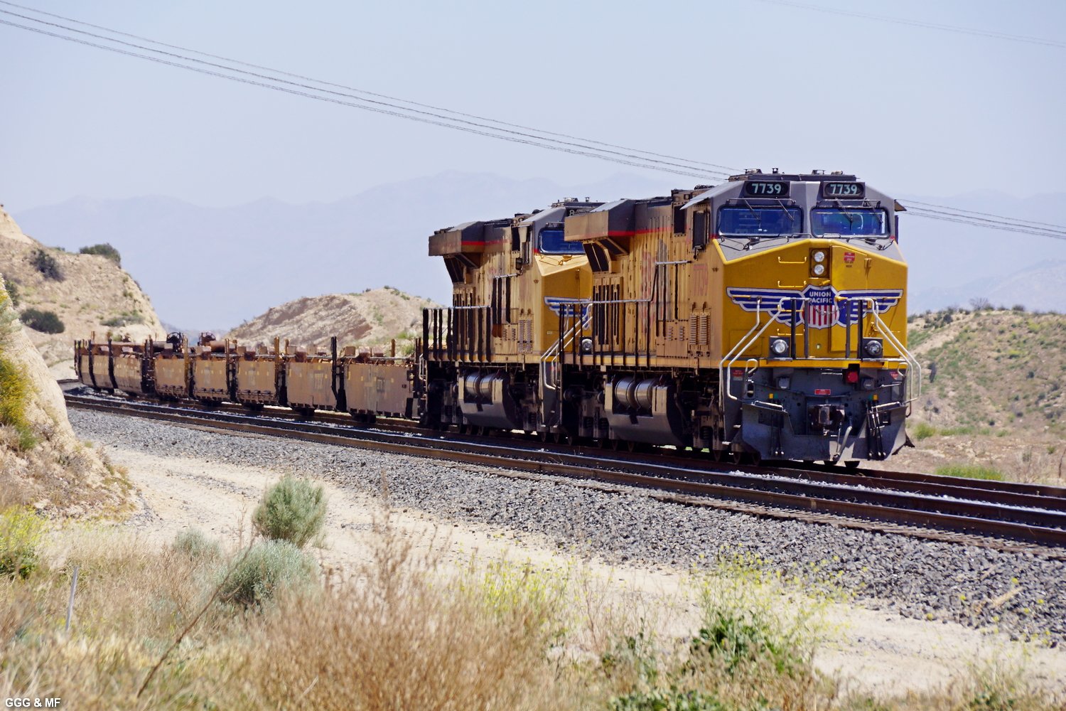
GGG 4/29/18 From the East end at Summit, the
new asphalt.
-
232 |
GGG 4/29/18 We used the USFS/UP road to
return to Oak Hills. Found UP 7739 South waiting at the UP HiLand siding. -
233 |
updated: June 12, 2018
|
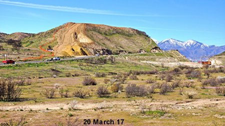
May 31, 2018: Highway 138
(East) Realignment Project - Final report |
The project to realign SR-138 is essentially complete
and the road is fully open to traffic.
The following pictures were all taken
near where the old original Summit overlook existed--BUT NOW 40+ feet lower.
The hill on the left of #234, although
not quite as tall as the old summit overlook, gives some idea of the former
height of the old SR-138 & observation point. BTW, there was a railfan with
camera, on top of that same hill --- quite a climb and looks a bit
dangerous.
Anyone visiting the area should
remember that the new speed limit is 55 MPH ---- which means 75 MPH to most
Kalifornians.
Entry & exit from this viewing area should be accomplished with GREAT CARE.
This
will probably be the last SR-138 update UNLESS something really interesting
happens --- BEEN FUN.
GGG |
 |
 |
|
GGG 5/31/18 East view from Summit Overlook -
234 |
GGG 5/31/18 West view from Summit Overlook -
235 |
|
#234 & #235: At the West end of Summit Hill,
between the hill pictured in #234 and the guard rail pictured in #235, there
is an opening and a small area which will accommodate a few cars and allow a
view of the BNSF Summit curve --- unless more guard rails are installed.
|
 |
 |
|
GGG 5/31/18 it shows the new & lower Summit
curve view. - 236 |
GGG 5/31/18 BNSF 8326 EB on MT-3 -
237 |
updated: August 19, 2018
 |
|
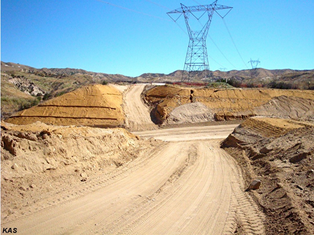
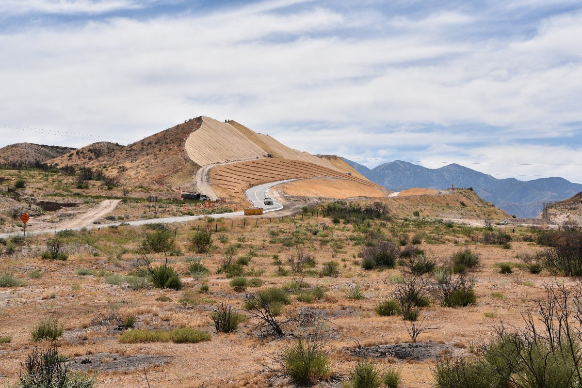
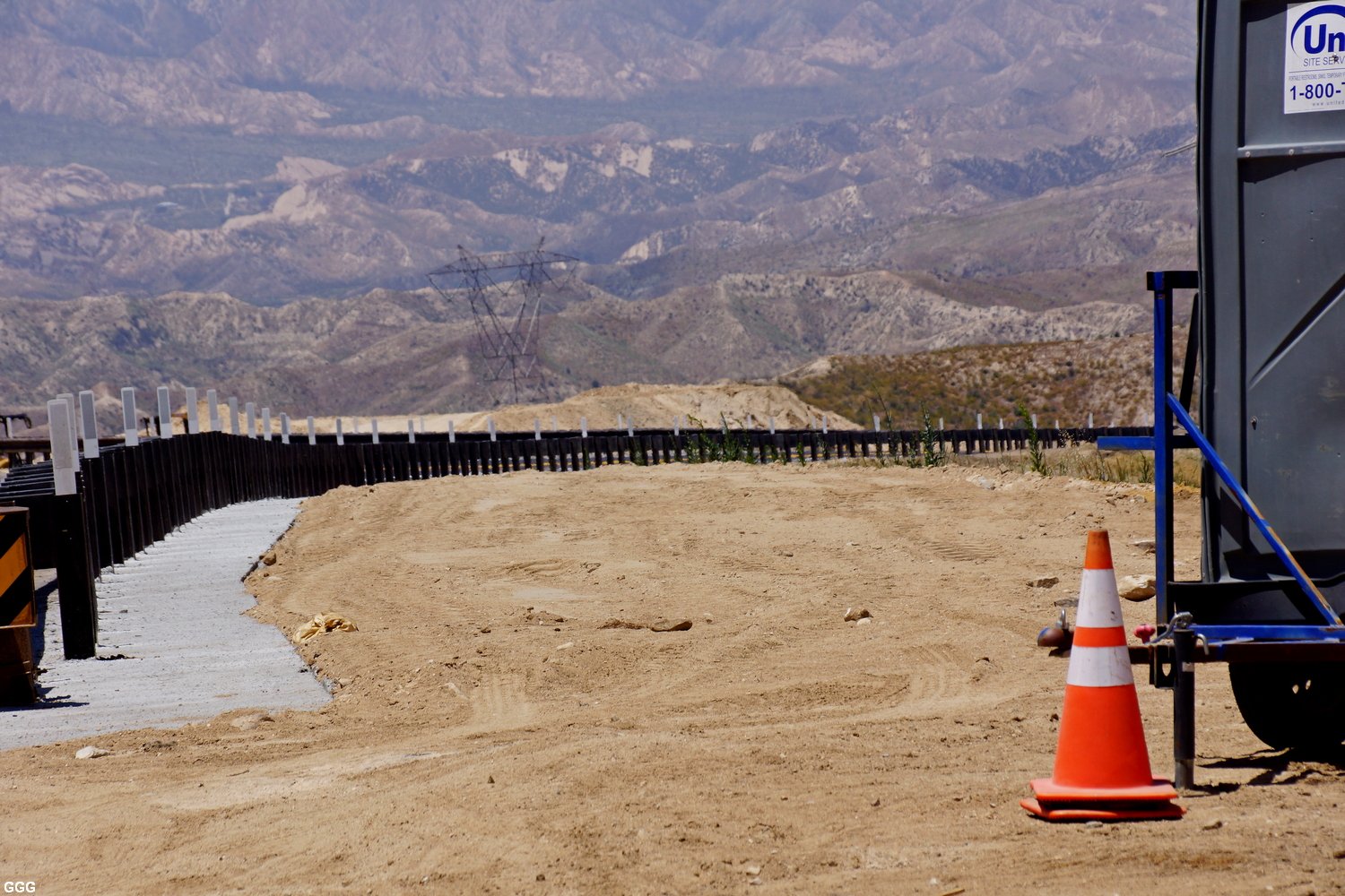
One last look at the SR 138. Dirt removed
from under the new bridges was used to rebuild the old 138 roadway up to,
what were once-long ago, the normal terrain contours. Picture taken from
Hill 582 on 8/17/18 by GGG - 8068 |
8 different and detailed Maps of Cajon Pass with
captions (Mile Posts and Location) by Gary G. Gray - click
here
New 8/11: Maps "How to find"
Hill 582, Sullivan's Curve, Noisy Point by Gary G. Gray -
click here |
|
Accurate Map of Cajon
Pass with 3rd Main Track by
Michael Amrine - click here |
Go back to Cajon Pass Main Page - click here
(over all copyright by Werner
Meer, Switzerland)
-GGG-09-30-17.jpg)
-GGG-09-30-17.jpg)
-GGG-09-30-17.jpg)
-GGG-09-30-17.jpg)
-GGG-09-30-17.jpg)
-GGG-09-30-17.jpg)
-GGG-09-30-17.jpg)
-GGG-09-30-17.jpg)
-GGG-09-30-17.jpg)
-GGG-09-30-17.jpg)
.jpg)