TRAINMASTER
BY WERNER MEER US-RAILROAD-SHOP KILCHBERG
HOCHWEIDSTRASSE 3 CH-8802
KILCHBERG (ZÜRICH) SWITZERLAND (founded 1977)
PHONE *41-44-715-3666, FAX
*41-44-715-3660, E-MAIL trainmaster@bluewin.ch
Go back to our Website - click
here |
added: July 7, 2010
/ updated: October 14, 2016
|
Cajon Pass Map with New
BNSF Third Main Track |
| We are very thankful to
Michael Amrine, who took the time to draw a special map
with all tracks over Cajon Pass as it is today, 2010. |
Elevation of BNSF Summit is 3777 feet - 1151 m
(I-15 Summit is 4190 feet - 1280 m)
We are having a great photo documentation of the 3MT Contruction by BNSF with
more than 900 photos.
Take a look, you will be impressed (links are below the
map).


© 2010 Michael Amrine - All Rights Reserved - graphicsmike@gmail.com
Did you see the fantastic Cajon Pass Photography by Michael Amrine on
railpictures.net? - click here
Below are links to the BNSF 3rd Main Track Project
Did you see page 1? - please click
here
Did you see page 2? - please click here
Did you see page 3? - please click here
Did you see page 4? - please click here
Did you see page 5? - please click here
Did you see page 6? - please click here
Did you see page 7? - please click here
Did you see page 8? - please click here
Did you see page 9? - please click here
Go back to 3rd MT Main Page - click here
Go back to Cajon Pass Main Page - click here
| MILEPOSTS (MP) between Barstow and San Bernradino over Cajon Pass |
|
The original track through Cajon was completed in 1885 with a
ruling grade of 3%. The MilePosts were numbered from East to West starting at
Barstow.
In 1913, a two mile longer second main track was
completed with a ruling grade of 2.2%. The NEW 1913 main became the NORTH (#1)
track while the original track became the SOUTH (#2) track. Since there was a
two mile difference in the tracks between West Summit Island and Cajon Jct, the
new MilePosts for the North track were given an "X" to denote a
separate track. When the #1 and #2 tracks returned to parallel running at Cajon
Jct, the newer North #1 track simply "lost" two miles and became
MilePost equal to the original track.
With completion of construction of the new Third Main track,
the "MILES" on MilePosts on the #1 and #2 tracks were lengthened to
about 1.15 miles each to coincide (at Cajon Jct) with the 1913 track Mile Posts.
In other words, for railroad purposes the distance between Summit and Cajon is
now considered to be the same for all three tracks, even though the actual
distance is 1.15 miles between mile posts on tracks #1 and #2.
|
| Barstow -
Summit |
Summit - Cajon
Station (2,2 %) |
Cajon Station
- San Bernardino |
| MP |
Location |
MP |
Location |
MP |
Location |
| 0.0 |
Barstow |
55.9 |
Summit |
62.8 |
Cajon Station |
| 6.7 |
Lenwood |
56.7X |
West Summit
Island |
63.4 |
Curved Bridge |
| 13.6 |
Hodge |
57.2X |
Silverwood -
Bridge USFS 3N45 |
64.4 |
Swarthout Canyon
Road X-ing |
| 21.1 |
Helendale |
58.2X |
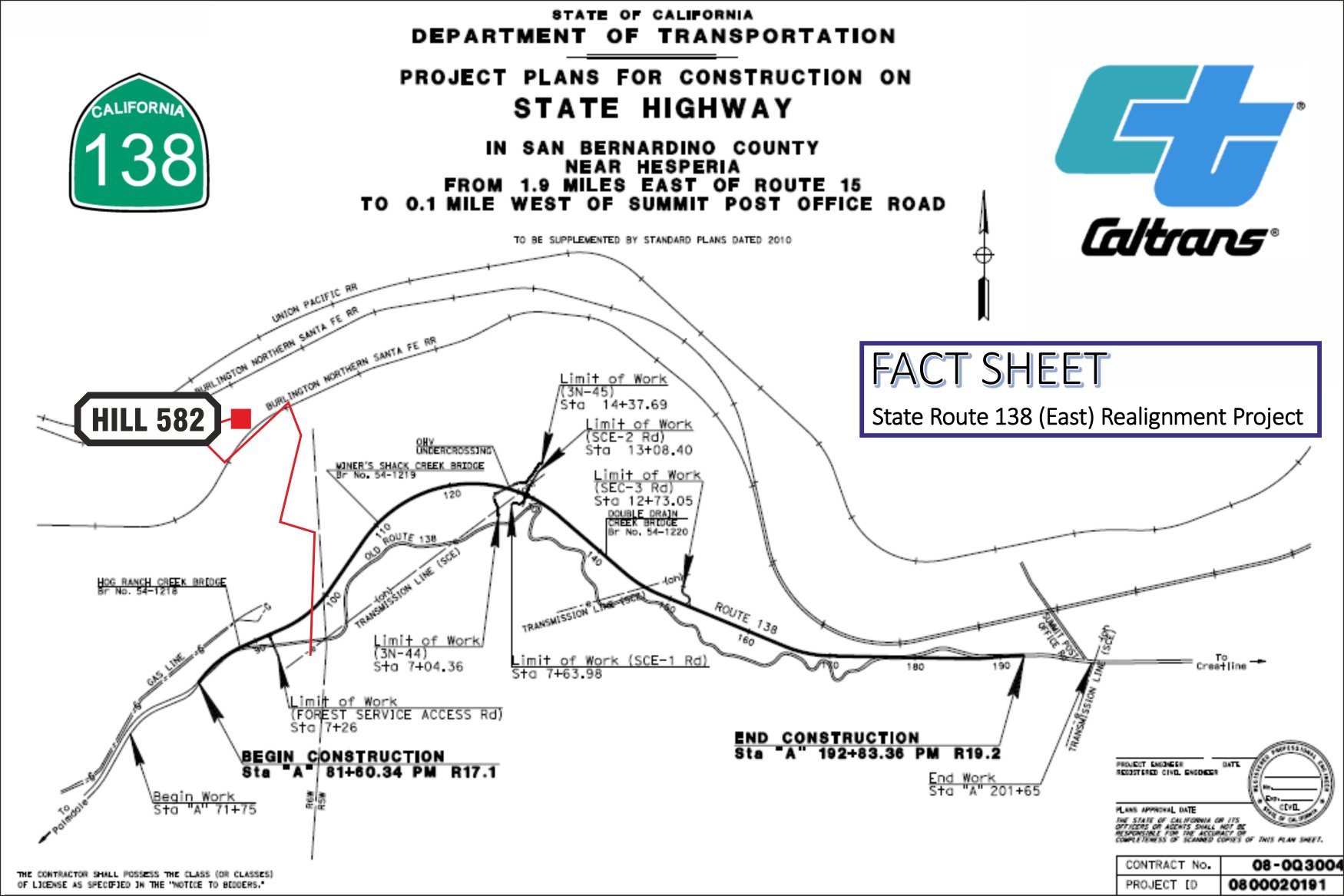
Hill 582 |
65.0 |
Blue Cut |
| 31.5 |
Oro Grande |
58.9X |
former Tunnel 1
(Alray) |
67.3 |
Old Keenbrook |
| 34.6 |
East Victorville |
59.2X |
former Tunnel 2
(Alray) |
69.4 |
Keenbrook |
| 36.7 |
Victorville |
59.5X |
Bridge over Baldy
Mesa Road |
71.0 |
Devore |
| 38.0 |
Frost |
60.2X |
CP Walker |
73.9 |
Verdemont |
| 39.1 |
Flyover |
60.6X |
Davis Ranch Road
X-ing |
75.0 |
Ono |
| 41.1 |
Thorn |
62.2X |
Pine Lodge -
Mormon Rocks |
79.9 |
Baseline |
| 45.1 |
Hesperia |
63.0X |
Sullivan's Curve |
80.6 |
7th Street |
| 50.1 |
Lugo |
64.1X |
Bridge over Cajon
Creek |
81.4 |
San Bernardino |
| 52.8 |
Martinez |
62.8 |
Cajon Station |
- |
- |
| 55.9 |
Summit |
- |
- |
- |
- |
8 different and detailed Maps of Cajon Pass with
captions (Mile Posts and Location) by Gary G. Gray - click
here
New 8/11: Maps "How to find"
Hill 582, Sullivan's Curve, Noisy Point by Gary G. Gray -
click here |
Go back to Cajon Pass Main Page - click
here
